Australia: The photo fly trap

photoflytrap

@RIV—RWoodger

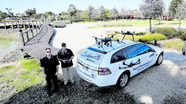
Barry Brown of Aerial Photography UAV – which is the only holder of an Unmanned Aircraft Vehicle certificate in the Echuca-Moama region – said there could be costly ramifications for those using an operator without proper accreditation.

‘‘The thing we’re trying to get people to realise is there are illegal operators out there,’’ he said.

‘‘Every one of them is breaking federal law whenever they fly within three nautical miles of a licensed aerodrome or a helipad – and this takes in all of Echuca and Moama.

‘‘They haven’t got insurance. They haven’t got qualifications. And if they fly and give you a photo and you use it for profit or gain, you are up for fines and so is he or she.’’

Under Australian civil aviation laws, individuals can face fines of up to $850 for a first-time offence.

Mr Brown said his business’ operations were overseen by the Civil Aviation Safety Authority, which required it to document each flight it made and any maintenance work it completed.

‘‘It is a lot of work and requires a high level of professionalism – that’s the difference,’’ he said.

‘‘As a commercial operator we have exemptions to allow us to fly within the three nautical mile limitations, but strict regulations apply.

‘‘The safety aspect is what I’m passionate about. You’ve got to shut down these back doors because they are going to hurt someone.’’

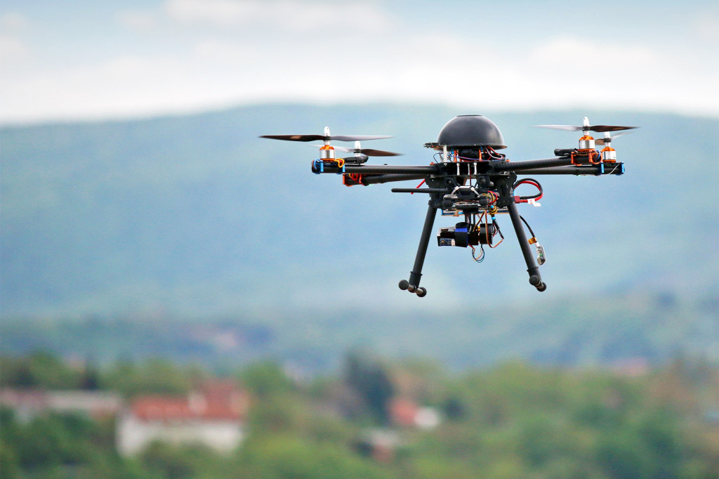
Mr Brown said his organisation only flew drones with six or eight motors to maximise public safety.

‘‘If a motor failure did occur the drone can be safely flown and landed, unlike the small drones with only four motors which will roll over and dive to the ground uncontrollably,’’ he said.

‘‘It could cause injury to persons or damage to property.’’

Mr Brown said it was still legal to fly a drone as long as it was in a non-restricted area and not above 400ft — and if images taken were not used for profit or gain.

http://www.mmg.com.au/local-news/echuca/the-photo-fly-trap-1.99634

Enlisting a Drone to Sell Your House Just Won’t Fly

oldoldquad

By Craig Donofrio

Once a novelty, high-def videos of homes with sweeping aerial shots like in a Hollywood movie have become a favored sales tool of real estate agents and homeowners.

Tempted to jump on the flying bandwagon to sell your house? You may want to put on the air brakes and educate yourself first.

Flying a drone isn’t like flying a hobby aircraft—not when it comes to selling your house. The rules were grayer when drone usage was in its infancy. But now that these flying gadgets have seemingly become as ubiquitous (and annoying) as mosquitos in some parts of the country, they’ve come under scrutiny by the Federal Aviation Administration. And the FAA has brought down the hammer.

Now, any time you want to use a drone for any commercial purpose (including selling a private residence), you’ll need to acquire a permit or petition the FAA for an exemption. It could take months, and there’s no guarantee the FAA will approve your request.

For individuals selling their own house, that’s a lot of hassle. Plus, drones can cost from a few hundred to many thousands of dollars, says Steve Metzman, president of the aerial photography business DroneLinx, which has offices in New York City andPhiladelphia.

Dangers of using drones

Why the governmental scrutiny? The FAA is concerned about the dangers of an untrained person piloting a drone, and also “personal injury, property damage, privacy and public nuisance” issues that can arise from your drone-flying escapades, says David P. Cooke, director of Genova Burns’ aviation and aircraft law practice group in Newark, NJ.

Beware of breaking—or bending—the rules by renting a drone (and not getting the permit/exemption) instead of buying one, or shooting the drone footage and having an editing company produce the video. Either way, you’re at legal risk, experts say.

Best legal way to sell your house with a drone

If you really want that vertiginous aerial panorama of your home, your best option is to get an FAA-approved company to do the work for you.

Some Realtors® and real estate companies may include aerial video as part of their package, by either hiring a third party or doing it themselves if they have the proper permissions and equipment. To make sure the company is operating legally, Metzman says to ask for its FAA authorization number.

The good news: The FAA has been issuing more exemptions than ever before. To date, it has approved 1,500-plus exemptions (and that number’s growing!) throughout the country. At the very least, you’ll be able to shop around.

http://www.realtor.com/advice/sell/enlisting-a-drone-to-sell-your-house-just-wont-fly/?iid=rdc_news_hp_carousel_theLatest

DroneDeploy Launches Free Map Processing For Any Drone

DroneDeploy Vineyard DJI no logo

(San Francisco) September 15, 2015 ­­ DroneDeploy, a Silicon Valley tech company that provides cloud–based aerial mapping software for commercial drone operations, announced today that they’ve made their software available for free to anyone in over 120 countries, providing users with the fastest solution available to automate their drones and receive detailed aerial maps and 3D models.

In addition to providing free, browser­based map creation software, the company announced a new feature called Map Engine, a way for businesses to easily create maps with any drone—regardless of manufacturer.

According to CEO Mike Winn, Map Engine was the logical next step for DroneDeploy. “In the past, DroneDeploy hasn’t been easily accessible to anyone with any drone,” said Winn. “That changes today. Map Engine is a way for any drone owner to create maps and 3D models by just uploading their data into DroneDeploy. And like the rest of DroneDeploy, it’s really simple and really fast, delivering most maps in under two hours.”

Users just need to upload aerial imagery into Map Engine and DroneDeploy’s servers handle the rest—producing fast maps and 3D models, stored in the cloud. “Needless to say, we’re really excited to get our mapping technology into more people’s hands and continue raising the bar in this industry,” touted Winn. “We have hundreds of users from all over the world that are extremely vocal about the ROI they’ve achieved with DroneDeploy.

Users in the agriculture, mining, construction, and surveying industries… to them, the potential for commercial drones is obvious—one of our key responsibilities is to advocate the value of drones for all businesses, so that everyone is aware.”

DroneDeploy’s free mobile app is currently available for Android devices through Google Play and lets users automate mapping flights for drones manufactured by DJI. An iOS app is slated for release in the coming months.

Map Engine is available today via open, opt­-in beta, through the DroneDeploy dashboard and is compatible with geo­tagged imagery from any drone. To opt­-in, click here.

http://droneblog.com/2015/09/15/dronedeploy-launches-free-map-processing-for-any-drone/

Geo-Fencing to Become Mandatory for Drones

drone-map

by

Geo-fencing may soon be used to control where and when drones fly.

It’s no secret that drones have occasionally gotten a bad rap by the media. Often presented as a Big Brother-esque ‘eye in the sky’, the concerns for safety and privacy are rising.

The geo-fencing debate has been making great waves in the US, with Senator Charles Schumer introducing a proposal to make it mandatory for all drone manufacturers.

Geo-fencing will use GPS to define boundaries and prevent UAVs from flying in certain areas or at certain times.

Chinese manufacturer DJI is set to introduce mandatory geofencing in order to prevent their kits from flying in restricted airspace over Washington DC. This comes after a DJI Phantom was found crashed on the lawn of the White House earlier this year. DJI spokesperson Michael Perry has added that they intend to expand on this in the near future and use geo-fencing in order to further restrict kits from flying in restricted areas. This would prevent drones from taking off in areas such as airport runways and government properties, and most recently, in the vicinity of natural disasters.

The latter comes after a recent issue in San Bernardino, California. Fire fighters were required to deploy aerial efforts to combat a bushfire, but were forced to jettison their loads and land their crafts due to drones flying overhead.


geo fencing picture

Geo-fencing will also be able to ensure drones don’t enter the flight path of commercial vehicles – a growing problem, according to Schumer. Recent data shows drone sightings by pilots have increased from 238 in 2014, to 650 so far in 2015.

In talks for the future is fencing around international boarders after another DJI Phantom was found on US-Mexico drive with cocaine strapped to its body.

While these events certainly prove unfavourable, it is evident throughout history that any new technology can be misused. Geo-fencing is a practical precaution to ensure that the use of drones stays safe and continues to benefit the public.

Interested in drone cinematography? Have a read through our recent blog to find out how your aerial cinematography could be showcased: World’s First Drone Film Festival – Flying Robot International. Make sure you don’t fly in restricted areas when shooting for the film festival!

CA: Bill on drones heads to Gov. Jerry Brown’s desk


mikeeaton2

By Joe Nelson, San Bernardino Sun

Legislation that would increase fines for drone operators who interfere with firefighters and other emergency responders has passed the Legislature and is headed to the governor for consideration.

State Sen. Ted Gaines’ proposed law would also grant immunity to firefighters and other emergency responders who damage or destroy unmanned aerial aircraft during emergency operations.

Senate Bill 168 passed the Legislature on Friday and was on its way Monday to the desk of Gov. Jerry Brown for consideration, an aide for Gaines said.

“To think that someone would interfere with firefighting or emergency response situations to get a sneak peak or to post a drone video on YouTube is an outrage that is deserving of punishment and condemnation,” Gaines, a Republican from El Dorado, said in a statement.

For firefighters, 2015 has been the year of the drone. Unmanned aerial aircraft have been popping up at wildland fires across the state this year, hindering firefighting operations, destroying property and threatening lives, authorities said. And Southern California — with fires across the San Gabriel Valley foothills to the passes and brush of San Bernardino County — has been no exception.

“Any effort by our elected officials, the public and hobbyists to make the skies safer for firefighters, we definitely appreciate,” said John Miller, U.S. Forest spokesman for the San Bernardino National Forest.

He said that within a five-week period in June and July, there were five drone sightings at four wildland fires in San Bernardino County, and there have been more than a dozen drone sightings at wildfires across the state this year.

“It’s now part of our new reality that everybody has to be on the lookout for these things, which is a place we weren’t in a couple of years ago,” Miller said.

The most recent incident occurred Sunday, when Cal Fire reported that a drone forced the grounding of two air tankers trying to drop retardant on a wildfire fire in Oakhurst in Northern California.

In August, as the Cabin fire raged on the upper slopes of San Gabriel Canyon in the Angeles National Forest north of Glendora, the Federal Aviation Administration enforced a temporary ban on the flying of drones.

That came after a series of fires in San Bernardino County, where drones flown by civilians interfered with major firefighting efforts.

http://www.dailynews.com/government-and-politics/20150914/bill-on-drones-heads-to-gov-jerry-browns-desk

Drone-Based Wind Turbine Inspection To Form ‘£4bn’ Market By 2024

windspect

a

Drones are playing an increasingly important rone in the maintenance of power-generating wind turbines, report finds

Drones may have a significant part to play in renewable energy, according to a new study, which found that drone-based maintenance services for wind turbines could amount to an industry worth nearly $6 billion (£4bn) in less than 10 years.

Colorado-based analysts Navigant Research, which focuses on emerging technologies, said it expected cumulative global revenue for wind turbine UAV sales and inspection services to reach that figure by 2024, with drones already gaining ground in this field, where they are proving “more than a novelty”.

Blade repair

Wind turbines, which typically stand hundreds of feet high, are in constant contact with the elements, and their blades require regular inspection to ensure they maintain efficient energy production, and to avoid the possibility of “catastrophic” blade collapse.

These inspections are currently carried out either from the ground, with limited effectiveness, or by access via ropes or platforms. Drones offer a middle option, Navigant said.

“Commercial-grade UAVs handled by professional operators can provide higher-resolution visual inspections than ground-based inspections,” the report explained. “They also provide an inspection that is quicker, easier, and less costly and risky than rope access techniques.”

Navigant added specialised drones are required for the task, since they must provide sharp optics and be able to maintain stability in strong winds.

“Equally important is the integration of data analysis systems and inspection services that can help automate data processing and analysis to mitigate the photo fatigue that can occur photographing, analysing, and cataloging vast blade surface image data across fleets of wind turbines.”

Drone growth

The market is already significant in size, with nearly 270,000 individual wind turbines operating globally at the beginning of 2015, with more than 800,000 blades spinning on these turbines, according to the company.

Drones are expected to play an increasingly important role in industries ranging from shipping and delivery services to agriculture, but have also spurred safety and security concerns, with a rapidly growing number of drone incidents in connection with commercial flights and at public events.

Last week California’s governor vetoed a law that would have curbed the use of commercial drones in the state.
Read more at http://www.techweekeurope.co.uk/e-innovation/drone-wind-turbine-176806#Fl7RspI1pI8ELG77.99

Registration open for GEOTech 2015

geotech20152

The Potomac Region of American Society for Photogrammetry and Remote Sensing (ASPRS) announces its 2015 GeoTech Conference focusing on Unmanned Aerial System (UAS) imaging systems.  The Conference will be September 23-24, 2015 at George Mason University in Fairfax, Virginia with the theme “Sensor Design Considerations for UAS Platforms”.  The event brings together the UAS platform and payload community with users of UAS imaging systems.  GeoTech 2015 promotes the exchange of information as the UAS market continues its rapid expansion.

Participants can expect to hear about the most recent advances in UAS platforms and sensors as well as how these sensors are being used by government departments, environmental groups, and commercial entities.  The conference will include exhibits by UAS-related organizations as well as a poster session for local college and university students to share UAS-related research.

GeoTech 2015 will have prominent thought leaders to provide keynote addresses:  Patrick Egan is the Editor of the Americas Desk at sUAS News, and is the host and Executive Producer of the sUAS News Podcast Series, Drone TV, and the Small Unmanned Systems Business Exposition.

Dr. Bruce Quirk is the UAS Manager at the U.S. Geological Survey and is the ASPRS UAS Division Assistant Director.  Additional industry leaders are participating from American Aerospace, Altavian, PrecisionHawk, Icaros, Visual Intelligence, Ready to Drone, the Open Geospatial Consortium, the North Carolina State University Institute for Transportation Research and Education, the Agricultural Research Service Hydrology and Remote Sensing Laboratory, and Botts Innovative Research.

Registration is now open for GeoTech 2015 at http://asprspotomac.org/events/geotech-2015/

Finland: Post Office tests drone for parcel delivery

finnishpost

Reuters

The Finnish postal service has begun tests with drones to deliver online purchases.

During the four-day test which started on Wednesday (September 2), the drones will be transporting parcels between mainland Helsinki and Suomenlinna, an island fortress some five kilometers from the city center.

According to Posti Group, it is the first company in Europe to experiment with unmanned aerial vehicles (UAV) for mail delivery in an urban area, with a flight path that is partially obstructed.

During the tests, parcels that weigh no more than three kilograms will be flown to the island by the drone, while letters and other parcels will be delivered the usual way by boat.

Jukka Rosenberg, Senior Vice President of parcel and logistics services at Posti, said the company was testing ways to make online shopping quicker and better for both the sender and recipient.

“This is part of the testing new technologies in our parcel delivery and post deliveries and this could be an opportunity which we are now testing,” he said following a press viewing on Tuesday (September 1).

The very first drone delivery went off without a glitch, even though it landed away from the designated landing zone.

Tero Heinonen from Sharper Shape, that is responsible for the technical aspects and operation of the drone, said safety was a priority and that the pilot had chosen a different landing spot because of the windy conditions.

“Safety is very important for us and the human pilot is always in charge of the flight and on this occasion it seems that the pilot made a decision to land further away from the crowd which had gathered here just as a safety precaution,” he said.

The parcel was then handed to the Minister of Transport and Communications, Anne Berner.

The test comes after her department drafted a program to promote intelligent automation.

According to Posti, Finland is at the forefront of using new technologies for transportation with legislation and public authorities strongly encouraging work in the field of automated traffic.

Heinonen said there was great interest in drone technology and said there were many potential uses.

“It seems that drones are one of the new technology areas which really ignite people’s imagination, so we get probably twenty requests per week for different applications that we ever could not have imagined. So I expect that while the technology further matures we will see many companies doing different kinds of applications starting from precision agriculture, forestry inventory, the deliveries of course, power-line inspections, counting traffic,” he said.

The announcement by Amazon last year of a potential drone-based delivery service has excited consumers, but a number of major obstacles remain before drone delivery services become the norm, namely weight limits, distance limits, and weather restrictions

http://uk.reuters.com/article/2015/09/14/us-finland-postaldrone-idUKKCN0RE15E20150914

IN: Wayne Township fire department begins drone operations

waynefiredrone

INDIANAPOLIS (AP) — A buzzing filled the air as the little white plastic drone lifted off, all four of its propellers whirring. Lt. Troy Wymer sent it zooming off across a grassy field, a tiny spectator looking down over the geese below.

In the future, Wymer is hoping to use the unmanned aircraft in less picturesque settings — supporting Wayne Township firefighters in all kinds of situations, from hazardous material spills to search-and-rescue operations.

Wymer is one of seven Wayne Township firefighters who were trained to fly the department’s two new drones, or unmanned aerial vehicles, this week. Capt. Mike Pruitt, the department’s spokesman, said Wayne Township is the first fire department in Indiana to use drones.

“I think back to hundreds of runs that it would have been so nice to have eyes on the top of the situation,” Pruitt told the Indianapolis Star. “Beforehand we either had to use a helicopter or get up in an aerial truck.”

For example, if a large building is on fire, the incident commander sitting in a truck can only see one side of the building, Pruitt said. With a drone, he or she could also see the other three sides, providing a better understanding of the situation.

And fewer firefighters would be put in danger if using a drone to investigate the extent of the blaze.

However the drones, which are about a square foot in size, are not a replacement, he said, for helicopters or on-the-ground manpower. They will mostly be used to gather information at the initial incident scene and report back in real time.

“One of the things that’s most important for first responders is situational awareness,” Wymer said. “Instead of a manpower-intensive operation, we can use something like this.”

Another benefit is that the drones, although they do have a 24-minute battery life, can be airborne within five minutes. Compare that with the time it would take to get a helicopter or even put on a hazmat suit.

Pruitt said the Wayne Township Fire Department first started thinking about using drones in April of this year, when they met representatives of SkyFire Consulting at a conference in Georgia.

SkyFire provides full-service consulting to fire departments looking to integrate drones into their procedures, from the drones themselves to handling the certification paperwork through the Federal Aviation Administration.

Each drone costs about $2,000. Overall, the entire project cost the fire department about $10,000, Pruitt said, including three days of training for the firefighters.

“Basically, we serve as their eyes in the sky,” SkyFire Director of Sales Walt Wylupek said. “It’s a lot safer to send in a $2,000 piece of plastic, rather than a human life.”

Drones and firefighters have been in the news recently as wildfires rage on the West Coast, but many of the stories are about privately operated drones interfering with aerial firefighting operations.

“There’s a lot of controversy right now, but safety is our number one priority,” Pruitt said. “We’re not going to be working at super high altitudes.”

And the pilots will be fully trained, unlike some hobby pilots. The department must obtain a certificate of authority from the Federal Aviation Administration to fly the drones, have written guidelines of how the drones are to be used and ensure drone pilots have passed the private pilot written test in addition to field training in operating the unmanned aircraft. Eventually, the FAA will make a site visit to ensure the pilots are fully capable, Pruitt said.

Once the pilots are fully certified and the drones are integrated into daily operations, Pruitt said the fire department is planning to share the use of the technology with other law enforcement agencies. Eventually, they may purchase more drones.

http://wlfi.com/2015/09/14/wayne-township-fire-department-begins-drone-operations/

Lost GoPro found: You won’t believe the video it took

Two Years in the making

Digital Reporter

Saturday, September 12, 2015, 3:20 PM – Two years ago a group of friends attached a GoPro camera to a weather balloon and sent it to the edge of space.

The balloon drifted out of cell phone tower range and they thought it was gone for good until earlier this summer, when they received a phone call from a woman.

She had been hiking when she came across a mysterious box that contained, among other things, a phone and a GoPro camera. She took it to an AT&T store and they were able to identify the owner of the phone via the SIM card.

Two years later the camera was still in working order and contained 1 hour and 38 minutes of amazing footage.

During the experiment the weather balloon climbed nearly 30 kilometres in the air and managed to capture a spectacular shot of the Grand Canyon.


Bryan Chan was involved in the experiment, which needed to be cleared with the U.S. Federal Aviation Administration prior to launch.

On the content-sharing website Reddit, he says the smartphone attached to the weather balloon was using an app that texted its location to the team as it descended back down to Earth.

“The problem was that the coverage map we were relying on … was not accurate, so the phone never got signal as it came back to Earth, and we never heard from it,” he writes.

The box containing the camera landed about 80 km from the launch site in an unpopulated area.

Chan says the experiment took four months to plan, and the group was upset when they thought they’d lost their camera for good.

“We were all moping around, making bets on when (if ever) it would be found … when just a couple months ago, a woman contacts us,” he writes on Reddit.

“We were all freaking out for a few days after we got a hold of all the video footage and data.”

Source: PetaPixel | Reddit


http://www.theweathernetwork.com/news/articles/lost-gopro-found-you-wont-believe-the-video-it-took/57041/