Author: mecicon
InterDrone Trade Show Video
UAV Mapping Pioneer along with Leading Industry Experts Launch SkyPoint Drone Consulting Group

Former UAV/Drone mapping pioneer and founder of one of the world’s first UAV surveying firms launches SkyPoint (www.skypoint.io), a group of UAV, Image Processing, Mining and Geomatics experts focused on drone + geospatial solutions. Their goal is simple – to assist businesses successfully implement drone technologies for geospatial applications
SkyPoint tailors drone mapping solutions to each customer’s unique needs, and helps establish their own in-house capabilities. Drone implementations can be complicated, expensive and risky. Having an experienced team to guide you during these early stages can greatly increase the success rate and lower the inherent risks of operating drones. SkyPoint personnel have been involved in all aspects of the UAV surveying industry – regulatory compliance, flight planning and ground survey, uav flight, data processing, marketing and branding, and R&D.
“A significant amount of time and money can be spent on drone technologies and mapping software/services which over promise and under deliver”, says Scott McTavish of SkyPoint. “We take an unbiased approach regarding platforms, sensors and software, and align the best solutions for the intended applications, budget and timeframe. Having over 7 years experience and 2000+ commercial flights gives one an unique perspective and understanding of UAVs and mapping solutions.” Although SkyPoint is relatively new, McTavish has added experts from various industries to the team. “We view drones and their related technology as a tool to safely and proficiently collect, assemble and deliver geospatial data…DATA being the keyword. Our team consists of industry experts in Mining, Aggregates, Surveying, Remote Sensing, Electrical Transmission and Oil/Gas. We understand how to solve industry specific challenges using this technology, and we’ve been doing it successfully for a long time.”
SkyPoint’s experts are able to assist organizations both experienced and new to drone mapping technologies, such as surveying and engineering firms who desire to run this as a service, or for businesses such as aggregates, mining or oil/gas firms who are seeking to add UAV solutions within the company. “We can also help out through any of the steps of the process,” says McTavish. “We offer a ‘menu’ of services all designed to fit the goal, budget and timeline. We believe in providing the best solution for long term success and profitability.” SkyPoint’s consulting services can range from short term assistance to longer term implementations and ongoing support.
About SkyPoint Drone Consulting SkyPoint Drone Consulting offers drone consulting services remotely and onsite through a distributed team in Canada, USA, Mexico and South America. They are a group of highly experienced and skilled drone, regulatory, geomatics, mining, photogrammetry and business consultants whose mission is to help drone based mapping, surveying and remote sensing organizations reach their full potential, in a timely manner and on budget.
For more information, contact SkyPoint at info@skypoint.io , web at www.skypoint.io and twitter @SkyPoint_Drones.
Kansas State University and PrecisionHawk developing UAS app that predicts corn production

MANHATTAN — A research and technology development partnership between two of the nation’s leaders in the unmanned aerial vehicles industry is taking flight.
Kansas State University recently signed a research partnership with PrecisionHawk Inc., a Raleigh, North Carolina, company that develops unmanned aerial systems, or UAS, and applications that manage the data collected by the vehicles while in operation. The partnership establishes the four-year project “Advancing an end-to-end solution for agricultural applications of unmanned aerial systems and remote sensing,” which begins in September.
“Our newly formed partnership with PrecisionHawk really illustrates how targeted corporate-sponsored research can advance not only private sector interest, but also the university’s mission of research, education and outreach at the same time,” saidKent Glasscock, president of the Kansas State University Institute for Commercialization, which facilitated the research partnership. “Because of how well the partnership is tailored for these interests, it’s a real win-win for both Kansas State University and PrecisionHawk.”
“This relationship underscores the kind of interdisciplinary breadth the K-State 2025 vision encourages because it encompasses corporate engagement and the university’s groundbreaking leadership in unmanned aerial systems education, research and operations,” said Karen Burg, vice president for research and professor of chemical engineering. “Unmanned aerial vehicles are an emerging technology that will support precision agriculture, and Kansas State University’s expertise in building and protecting global food systems makes us a great fit for this kind of collaboration.”
Under the project, a Kansas State University agronomy expert and researchers at Kansas State University Salina are using their expertise to help PrecisionHawk create apps and programs that turn the aerial images of corn fields — and eventually other field crops — into useful data about a potential crop production issues, such as yield-limiting factor and characterization of yield potential, such as plant growth.
“There has been a big boom in UAS use and in the data being collected,” said Ignacio Ciampitti, assistant professor of agronomy and the project’s lead. “The key issue now is not whether this technology can collect the images we need, but how we can translate those pictures into scientifically sound and useful information. With this project we’re creating tools that farmers and agronomists can use on these pictures to get information about a crop, such as its potential productivity, and then adjust their practices based on the tools’ results.”
Researchers at K-State Salina are conducting flights to determine what photo and video sensors work best to get the maximum information about a field while a vehicle is in flight.
Ciampitti is taking information from the images and helping develop algorithms that can be converted into computer software or apps for PrecisionHawk’s Algorithm Marketplace, a recently launched app store with data analysis tools for the UAS market. The store is meant to simplify how UAS operators interpret data collected from a vehicle’s geographic information system during flight. The marketplace currently has apps that include counting the plants in a field and estimating the plants’ health once the crop matures.
The resulting app from the Kansas State University-PrecisionHawk partnership will be able to connect information collected via imagery with support decision tools to estimate yield response to varied management practices with the final goal of predicting site-specific yield potential. Ciampitti anticipates this technology also will be used to predict similar outputs for soybeans, sorghum and other crops.
“Kansas State University has an international reputation for excellence in agricultural research and an innovative approach in adopting new technologies,” said Allison Ferguson, director of education and research partnerships at PrecisionHawk. “Aerial data is an exciting and new component of precision agriculture, but in order to leverage its full potential, growers need more than imagery from a UAV. Through this partnership, we are committed to the development of critical decision-support tools to provide growers with information to advance agricultural productivity through the Algorithm Marketplace.”
Kansas State University and PrecisionHawk are both members of the Federal Aviation Administration’s Center of Excellence for Unmanned Aircraft Systems.
http://www.suasnews.com/2015/09/38556/kansas-state-university-and-precisionhawk-developing-uas-app-that-predicts-corn-production/
FAA declares no-drone zones for Papal visit
Bart Jansen, USA TODAY
Drones are unwelcome as Pope Francis visits his flock this month in New York, Philadelphia andWashington, D.C.
The Federal Aviation Administration designated all three areas no-drone zones to prohibit remote-controlled flights from Sept. 22 through Sept. 27. The prohibition is part of broader restrictions to limit unscheduled flights around the Pope’s various events as a security precaution.
“If you plan to attend any of the Papal visit events, please leave your drone at home,” FAA Administrator Michael Huerta said. “Anyone flying a drone within the designated restricted areas may be subject to civil and criminal charges.”
Drones are typically prohibited at large gatherings such as sporting events, and flight restrictions already blanket the Capital for national-security reasons.
But the D.C. no-fly zone has been expanded to aircraft at small airports in Maryland such as Potomac Airfield, College Park and Washington Executive/Hyde Park.
The Pope is scheduled to arrive Sept. 22 at Joint Base Andrews near Washington and then meet with President Obama at the White House the next day. The Pope will speak Sept. 24 to a joint session of Congress.
He meets Sept. 25 with the United Nations General Assembly, followed a procession through Central Park and a Mass at Madison Square Garden.
From New York’s John F. Kennedy airport, the Pope travels Sept. 26 to Philadelphia, where he will hold Mass is at the Cathedral Basilica of Saints Peter and Paul, and visitIndependence Hall.
He departs for Rome the next day.
Canada : KAP doesn’t want new UAV reglations to unnecessarily ground farmers

Unmanned air vehicles (UAVs), also known as drones, need regulation to ensure safety but the rules shouldn’t be so onerous as to prevent farmers from flying them, says Keystone Agricultural Producers (KAP) president Dan Mazier
“KAP would like dialogue before they (Transport Canada) make regulations,” Mazier said in an interview Sept. 3. “If they are going to put a certain regulation in at least consult farm groups or farmers and ask how they can work with it.
“This is supposed to be another tool for farmers. If they make it too onerous to get a licence or to use it they just won’t do it and there will be a lost technology that we just won’t be able to access because it’s just too much hassle.”
That’a the message KAP delivered in a submission, including nine recommendations, to the Canadian Aviation Regulations Advisory Council (CARAC) last month. The council, a joint effort of Transport Canada and the Canadian aviation industry, consults with the public on aviation regulations.
In 2016 Transport Canada says it will amend regulatory requirements for UAVs 25 kgs or less that are operated within visual line of sight. The changes are to ensure the safe operation of UAVs in Canada and will:
- Establish classifications, including a proposal for the possibility of having a very small (lower threshold) category of aircraft.
- Clarify terminology.
- Establish aircraft marking and registration requirements.
- Address personnel licensing and training.
- Create flight rules.
Transport Canada also says it will preserve the Special Flight Operating Certificate (SFOC) process for higher-risk operations, including UAVs larger than 25 kgs and those operated beyond visual line of sight.
Transport Canada is also proposing pilots flying small UAVs engaged in complex operations be properly trained and required to obtain a pilot permit by taking a test.
Thanks to lower prices and improved technology UAV use has taken off. In 2014 Transport Canada says it issued 1,672 SPOCs compared to 345 in 2012. That’s almost a fivefold increase over two years.
UAVs are increasingly popular among farmers and those working for them. They are a fast and efficient way to check crops and livestock.
To accommodate their growth in November 2014 Transport Canada adopted an interim strategy issuing two exemptions to the SFOC requirements and guidance material for lower-risk UAVs operating within specific conditions and weighing 25 kgs or less. Users operating a UAV weighing more than 25 kgs, or operating in higher-risk environments, still must apply for an SFOC. The exemptions are valid until December 2016.
KAP says the new regulations need to be flexible and reflect the risk, Mazier said. Tighter regulations make sense close to large urban areas where air space is busier and there are more people and buildings. But less oversight is needed in rural areas with lower populations and less congested skies, he said.
http://www.manitobacooperator.ca/crops/kap-doesnt-want-new-uav-regs-to-unnecessarily-ground-farmers/
AR: New policy restricts unmanned aircrafts on Capitol grounds
LITTLE ROCK, Ark. (KTHV) – With the recent rise in use of unmanned aerial vehicles, including model aircrafts and drones, the Arkansas State Capitol Police have implemented a new policy restricting their use over Capitol grounds.
The restrictions include aircrafts for recreational use, commercial use, or for any other purpose.
According to a press release, the designated area to which these restrictions apply includes the Capitol Building and the area immediately surrounding the Capitol grounds. The exclusion zone is bounded by I-630 on the south to Markham Street on the North and Victory Street on the east to the railroad tracks on the west.
“We have been discussing this issue for over a year and have determined these restrictions are necessary for the safety and security of the Capitol, its visitors, and employees,” said State Capitol Police Chief Darrell Hedden.
Any person determined to be in violation of this policy will be subject to criminal and civil penalties and liability under both state and federal law.
Any incidents violating this policy will be reported and filed with the State Capitol Police and the Federal Aviation Administration. Any devices involved will be seized and retained for the duration of the investigation. Any unclaimed aircraft seized by State Capitol Police will be destroyed 90 days after the end date of the investigation.
The use and operation of unmanned aircraft systems is strictly regulated by the Federal Aviation Administration and is also governed by state law. Any person who observes the use of an unmanned aircraft system or model aircraft on the State Capitol Grounds or within the bounded exclusion zone should immediately notify the Arkansas State Capitol Police at 501-682-5173.
http://www.thv11.com/story/news/local/little-rock/2015/09/15/new-policy-restricts-unmanned-aircrafts-on-capitol-grounds/72326886/
FAA drone deadline looms as apps bloom
 (concept w / Shutterstock)
What: “The First 1,000 Commercial UAS Exemptions,” a study released by the Association for Unmanned Vehicle Systems International that breaks down data about the first commercial exemptions granted for unmanned aerial drones in U.S. airspace.
Why: The Federal Aviation Administration’s deadline to work unmanned aerial systems safely into U.S. commercial airspace looms on Sept. 30, although the agency has hinted it is probably going to miss the mark.
At a Sept. 10 House Judiciary Committee’s Subcommittee on Courts, Intellectual Property, and the Internet hearing on the applications of unmanned commercial aircraft and public policy, Rep. Darrell Issa (R-Calif.) said the Obama administration had “essentially punted” on the rules.
The “inaction of the FAA,” he added, can’t stifle commercial development of the technology.
AUVSI said its study shows some of the commercial application diversity, as well as “a commercial market waiting to be unleashed.”
The FAA has been working since last May to approve commercial plans ahead of the deadline. As of Sept. 1, according to the study, the agency has granted 1,000 petitions for exemptions to operate unmanned commercial aerial systems commercially in the National Airspace System without an airworthiness certificate. The agency approved the first set of commercial operators on Sept. 25, 2014, to six film and television production companies.
In the first year of accepting exemption requests, the study found that the FAA approved almost 500 out of about 1,500 petitions, and as of Sept. 1, it had approved 1,407 out of more than 2,650 petitions. The agency continues to approve 50 new operations a week by rolling out a summary grant process in which similar petitions are batched and analyzed together rather than individually. However, the report said, the number of applicants continues to greatly outpace approvals.
The study found that operators have been approved in 49 states, with California containing the most with 114 operators, followed by Florida with 97 and Texas with 82. Delaware and the District of Columbia had no operators.
California companies made the most unmanned aerial system platforms with 140 manufacturers. Florida follows in second place with 19. In all, said the study, 22 states have unmanned aerial system makers.
Exemptions granted by the FAA cross more than 25 major industries, led by general aerial photography, which was mentioned in 512 of the first 1,000 exemptions. Real estate, general aerial surveying and agriculture were among the other leaders.
Verbatim: “It is clear in the data that, even though many industries have started to benefit from UAS operations, beyond-line-of-sight operations, operations over congested areas and nighttime operations will be critical to achieving the full societal and economic benefits of UAS use. To achieve this, a risk-based, technology-neutral regulatory framework will be essential to getting this industry off the ground.”
http://fcw.com/articles/2015/09/14/faa-drone-deadline.aspx
Falling drone injures 11-month old near Pasadena City Hall
By Jason Henry, San Gabriel Valley Tribune
A falling drone cut and bruised an 11-month-old girl in a stroller at an event Saturday, according to the Pasadena Police Department.
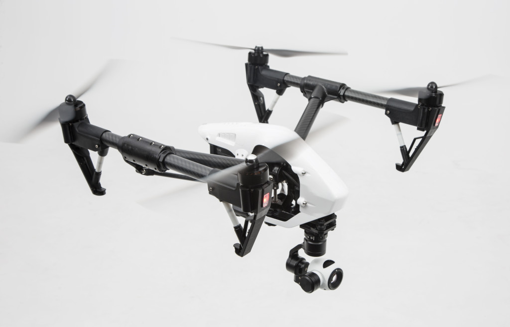
Police said a 24-year-old man lost control of his DJI Inspire 1, a camera-carrying quadcopter costing nearly $3,000, causing it to crash to the ground outside of City Hall during a movie screening.
“It lost its signal and ultimately crashed on Marengo Avenue and the debris from hitting the ground went out and hurt the child,” said Lt. Mike Ingram, with the department’s air operations. “It could have been much worse.”
The little girl received a quarter-inch cut on her head and a bump on the forehead, police said. She was treated at Huntington Memorial Hospital and then released.
It’s unclear what caused the drone’s descent, but police said the operator flew outside his visual range, losing track of the quadcopter. The operator did not face any charges, but police forwarded the accident to the Federal Aviation Administration’s Field Standards District Office in Van Nuys for review. The FAA could fine the operator if he’s found to have flown recklessly.
He said the Pasadena police department urges drone operators to use “common sense” and to follow the guidelines released so far by the FAA.
“It’s an exciting technology, it just needs to be used appropriately so no one is hurt,” he said.
Ian Gregor, an FAA spokesman, said Tuesday that the agency is investigating the report.
“The FAA is concerned with the growing number of reports about unsafe operations and is stepping up both its education and enforcement efforts,” Gregor said. “Anyone who flies carelessly or recklessly can face fines from $1,000 to $25,000, depending on the seriousness of the violation.”
Gregor said the FAA has initiated more than 20 enforcement cases, settled five where the operators paid fines, and has proposed penalties in at least five other cases.
The FAA advises operators to keep drones below 400 feet and away from unprotected people and vehicles. Drones must be operated within line of sight of the pilot and avoid interfering with manned air crafts, Gregor said.
Drone hobbyists in Southern California have attracted a lot of attention this past summer, with the state and local cities eyeing legislation to rein in their use, particularly during wildfires. Drones delayed fire fighting efforts in San Bernardino County earlier this summer, as they present a risk for aircrafts dousing the fires.
GIZMODO : GoPro Falls Off Drone and Into Burning Man Rave, Loathing Ensues
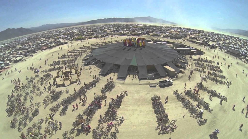
A maybe fake video of a GoPro tumbling off of a drone and landing on the main dance floor at Burning Man has emerged. It is now a perfect testament to what makes those three things—GoPros, drones, Burning Man—so annoying.
GoPros are annoying because nobody really cares about your action-packed life, when it mainly features your wacky face screaming at the camera. (The view from the ankle of an insane dirt bike rider doing a Superman jump is another story.)
Drones are annoying because when they drop their GoPros, they might hit someone in the head and possibly hurt them very badly. (Not even muddy, hungry pigs are safe any more.)
Burning Man is annoying because, well, it’s Burning Man.
http://gizmodo.com/gopro-falls-off-drone-and-into-burning-man-rave-loathi-1730833225