Media Madness

You know we have gone mainstream when Coke and Pepsi are using quadcopters/multirotors in their commercials.

Just a few examples:


Audi A6


Bud Light Lime


Neymar, Jr for Panasonic


Pepsi Drone Football


And of course Coca Cola


CNET en Espanol


Wrong on so many levels…puppies


Head and Shoulders…seriously?


Netflix


Position Challenges Flying an UAV Near North Pole Faced

18/08/2015

Engineers on board the Alfred Wegener Institute’s research icebreaker Polarstern have programmed a multicopter, allowing it to navigate despite the deviations produced by the Earth’s magnetic field near the North Pole. The researchers recently celebrated the copter’s first successful autonomous flight and landing on an ice floe.
 

Multikopter_Polarstern_006_SLehemenhecker

According to Sascha Lehmenhecker, an engineer at the Alfred Wegener Institute, Helmholtz Centre for Polar and Marine Research (AWI, Germany), experienced that flying on high latitudes, autonomous navigation is a major challenge. Navigation systems normally use magnetic sensors. Near the poles, the lines of the Earth’s magnetic field are nearly perpendicular to the ground, making precise navigation difficult. That’s why commercial multicopter control systems aren’t well suited for use in polar regions.

Ice Floe and Ship in Motion

Together with the PhD candidates Michael Strohmeier and Tobias Mikschl from the University of Würzburg, Lehmenhecker refined the control systems for multicopters – roughly half-metre-long devices, powered by multiple propellers, intended to land on ice floes and fly back to their ‘mother ship’ autonomously several hours later. The task: both the ice floe and the ship are in motion. The ship has to continue on its scheduled course to conduct other research, while wind, waves and currents cause the ice floe to drift. And it’s precisely the direction and speed with which it drifts that the multicopter needs to determine.


The development team pursued two approaches to allow the multicopter’s control system to compensate for the distortions in the positioning. In the first approach, the multicopter remains in constant contact with a receiving station, using the copter’s GPS data to calculate the discrepancies. The second option is to use two onboard GPS receivers to calculate the actual change in the copter’s position. Though this is a better method, it’s also much more complex, and the researchers were starting to develop it.


The system passed its first test, conducted on an ice floe in the arctic Fram Strait (79° N parallel), with flying colours: the team and copter were left on a floe. Now clear of the magnetic interference produced by electric motors on board the Polarstern, the team manually flew the copter roughly three kilometres out, to the edge of visual range. They then activated the autonomous return programme – and the multicopter flew to the pre-set coordinates and safely landed on its own.

Connection to Under-ice Use

Sascha Lehmenhecker and his colleagues in the AWI Deep-Sea Research Group came up with the idea for this development in connection with the use of sensitive devices under the ice. One example is the Group’s torpedo-shaped autonomous underwater vehicle (AUV) Paul, which explores the ocean beneath the sea ice. Conventionally, postion information was achieved by deploying ice trackers on floes with the help of a Zodiac boat or a helicopter – a difficult and time-consuming method. Further, the researchers generally try to avoid leaving the safety of the Polarstern wherever possible as water temperatures hovering around the freezing point, jagged ice floes drifting to and fro and polar bears, represent additional risks and should be kept to a minimum.


The Deep-Sea Research Group first used a multicopter developed by the AWI during a 2012 expedition. Flying by remote control, it landed on the ice and used GPS to determine its position, then transmitted the data back to the research ship, which was monitoring Paul’s dive. In this way, the multicopter offered navigational support for the AUV. Once each dive was complete, the ship had to return fairly close to the multicopter’s position: the pilot had to remotely guide the copter back to the ship, which was only possible in visual range. Extremely pleased by the successful test, which was conducted under the auspices of the Helmholtz Alliance ‘Robotic Exploration of Extreme Environments’ (ROBEX), Sascha Lehmenhecker recaps that this new development will expand the service radius of our copters from visual range to as much as ten kilometres.


http://www.hydro-international.com/news/id7969-Position_Challenges_Flying_an_UAV_Near_North_Pole_Faced.html

Amazon’s (Not-so) Secret Drone Test Site

by: Gary Mortimer • 16 August 2015

A rumour and purple tent was all it took for GeekWire’s Jacob Dement to claim a secret Amazon drone testing site.

There I was, air conditioner blasting in my Car2Go as I sat in front of a red gate on a gravel road in rural Snoqualmie, Wash. Multiple locals told me this was what I had come looking for: the entrance to Amazon’s secret drone testing site.

I wasn’t lucky enough to show up on a day when Amazon’s prototype delivery drone was being tested. But then I pulled up Google Maps to try to get a sense of where exactly I was.

And that’s when I saw it.

This satellite image, taken on a previous day, shows activity in the area beyond the gate. You can see a couple dark objects on the ground at either end of the image, what looks like a purple tent, a white van and some other vehicles — exactly where people in the area told me they’ve seen Amazon’s team set up.

Does it really matter if some Amazon employees are off multirotor flying somewhere?

We know they are!

Lets find some facts for Jacob, all thanks to published data from the FAA.

Long time sUAS News readers will be aware of our Drone Spotters collection of drone tail numbers from around the world, set up to monitor who was selling what to where. I notice Amazon registered its third official drone. N394PA appeared on the register just last Thursday.

We can learn some stuff from their naming, its a mark 24, so I think it’s fair to assume the 24th type of prototype and its serial number 14 so there are at least 14 mark 24’s out in the wild.

It joins N391PA and N392PA, serial numbers 6 and 8 respectively.

N393PA is not going to happen as it’s already allocated to an autogyro.

The questions I would ask is have they distributed other airframes to test simultaneously around the world and are Amazon just creating marketing footage in the USA?

Flying around a bit at the end of a track is hardly testing detect sense and avoid. Its not probing the platforms sensitivity to EMF. Its not testing a whole host of things.

Jacob, please do me a favour pop back and see if you can find a second site. One about 5km away. One that Amazon might be flying test deliveries to. That would be the sort of thing I would be testing to a track in the middle of nowhere.

Jacob also head off to Walmart and buy a scanner Unidenscanner

Then listen out on the local air traffic frequencies just in case the Amazon guys are doing the right thing and calling their position for VFR traffic in the local area.

It might also be worth dropping into Fall City Airport and finding out if any Amazon execs have flown in. They probably have a working relationship with the test team.

I would do it myself but its Sunday morning in South Africa and time to go out for a family breakfast. (some time passes) After breakfast I found the spot, skip to the bottom.

Here’s what Amazons Paul Misener, Vice President, Global Public Policy had to say last year in their FAA 333 exemption.

Our R&D operations will provide for a level of safety that far exceeds the level of safety required by FAA for hobbyists and manufacturers of model aircraft. The following operating procedures will apply during the R&D testing conducted under this exemption request:

  1. The sUAS will (i) have a maximum weight of less than 55 pounds; (ii) be rotor‐ powered via a battery source; and (iii) be U.S.‐registered and display marks in accordance with 14 C.F.R. Part 45, Subpart C.5
  2. Our sUAS R&D testing under this exemption will be conducted (i) within the visual line of sight of the operator and/or one or more observers; (ii) at less than 400 feet AGL; and (iii) within Class G airspace.
  3. The operations will be conducted in a confined area over isolated Amazon private property located a sufficient distance away from (i) any airport, heliport, seaplane base, spaceport or other location with aviation activities; (ii) any densely populated areas; and (iii) any military or U.S. government installations or airfields.6
  4. All operations will remain within the lateral and vertical boundaries of the operating area, taking into account all factors, including wind, gross weight and glide distances, that may affect the capability of the sUAS to remain within the airspace boundary; moreover, the integrity of the operating area will be reinforced by geo‐fencing,7 including the ceiling height of no more than 400 feet AGL.
  5. Our sUAS R&D testing under this exemption will be conducted (i) under the supervision of a designated pilot in command (PIC) who has final responsibility for the operation in accordance with 14 C.F.R. § 91.3 and either (A) holds a current FAA private pilot certificate issued under 14 C.F.R. Part 61, Subpart E, a higher FAA pilot certification, or a FAA‐recognized equivalent8 or (B) has completed FAA private pilot ground instruction and passed the FAA private pilot written examination or FAA‐recognized equivalent; and (ii) using only operators that have completed training on the normal, abnormal, and emergency procedures in specific details and demonstrated proficiency with the sUAS being operated.
  6. No operator or observer will engage in, nor may an operator or observer permit, any activity during a critical phase of flight which could distract any operator or observer from the performance of his/her duties or interfere in any way with the proper conduct of his/her duties.
  7. Operators will maintain the sUAS system in a condition for safe operation, and conduct a pre‐flight inspection prior to each flight so as to ensure that the sUAS, control station, data link equipment, payload, and support equipment are in a condition for safe operation and in a configuration appropriate for the purpose of the intended flight.
  8. The operators and observers will maintain two‐way communications with each other during all operations; if unable to maintain two‐way communications, or if any condition occurs that may otherwise cause the operation to be unsafe, the operator will immediately conclude the operation.
  9. Each sUAS will safely stop operating and return automatically to a specific location on Amazon’s private property if the communications link is lost.
  10. For each sUAS, the observer will have the ability to press a physical button, that will be within his/her reach at all times, that reduces power to the vehicle so as to force a controlled landing; both the hardware and communication for this safety system will be physically separate from the sUAS flight control systems.
  11. Testing operations will be conducted on private property, and only Amazon employees, contract personnel, and invitees will be invited to the operations area; security measures will be put in place to deter unauthorized access.

A gentle VR flight and I found where it is

amazonssecretsite

amazonssecretsite2

I guess distance is a relative, living as I do in Africa 45 minutes very often is the minimum you have to travel for more life. I have lived in places where an aeroplane was the only way to the shops.

With that in mind, this line…

So I grabbed a Car2Go in Seattle and made the 45 minute drive out into the middle of nowhere. It’s the kind of place where “No Trespassing” signs outnumber doorbells and people don’t seem fond of strangers wandering on to their front porches.

Then checking, its 6 minutes to the nearest African sounding joint, Sahara Pizza (tenuous I know) Raised a smile here. Also amusing the railway stations of startup and goldbar to the right of the title map. That’s why I made it so wide.


http://www.suasnews.com/2015/08/37836/amazons-secret-drone-test-site/

North American drone meet takes place in Stephentown

stevensonfpv

By: Asa Stackel

In Stephentown around noontime Friday, they weren’t the drones you’re used to.  Flying in a park field of NY-22 were fixed wing FPVs or First Person View drones. With the goggles, it’s like you’re actually on the aircraft.

“We fly it FPV, through this little camera here. The video transmits through this little antenna here,” said Josh Noone, drone pilot.

Josh, along with almost a hundred pilots from across North America are in Stephentown flying all kinds of FPV drones. Most build those foam “spec wings” themselves and most do it just for fun.  But that doesn’t mean they aren’t concerned with the controversy surrounding drones.

“Drones get a bad rep, unfortunately, I think there’s a lot of paranoia with the cameras that are attached,” said Thomas McCullough, NEFVP.

Adam Sloan of Birds Eye View Aerobotics sells a drone that can lift vertically like a helicopter and fly forward like a plane. Hobbyists use it, but it’s used in mapping, power line inspection, and agriculture.

“I just think the FAA has been dragging their feet on this technology for over ten years,” said Sloan.

Right now, each person interested in flying to make money has to get specific permission from the Federal Aviation Administration to fly. Sloan wants the FAA to relax the rules.

“I would like to see some common sense guidelines. We never have any need to go above 400 feet, manned aircraft have no need to come below 500 feet. There’s already natural stratification there,” said Sloan.

Unlike Adam, Most drone pilots are in Stephentown for fun.

“When they rip through the finish line, it’s like wah, wah, wah. It sounds awesome,” said Noone.

They just everyone to know how fun it is.


http://wnyt.com/article/stories/s3879747.shtml


DRONES: What are the rules of flying?

modelclubflying

BY ALEX GROVES

Sweeping aerial views, descents into rugged canyons and swift yet steady movements across landscapes – these are just some of the sights captured by camera drones.

The unmanned aircraft have produced captivating video and provided hours of fun for operators. In the process, they have swelled into a niche market, becoming one of the hottest-selling tech items in the country.

But they also have created headaches.

They have been a serious issue for pilots, who have had close calls during firefighting aerial drops and airport landings. Social media posts about privacy invasions – real and perceived – plus news stories about vigilantes destroying bothersome drones have highlighted other problem areas for the aircraft.

Harry Horlock, a 93-year-old drone enthusiast, said he can understand the pull and fun of flying a drone. Yet people need to take a commonsense approach when operating them, he said.

“It’s up to each individual,” he said. “They’ve got to use their own head.”

A member of the Temecula Valley Flyers, Horlock flies drones because he said they are easier to use than fixed-wing model aircraft. He said he flies them in a field near Temecula Valley Wine Country and even keeps his flight limited to certain areas of the field that are away from parking lots and other traffic.

The rapid growth of drones has outstripped the rules and etiquette governing them. But hobbyist organizations and government agencies are catching up.

One thing appears certain: Drones are here to stay.

Scot Demmer, a partner in Corona-based drone company PMG Multi-Rotors, said his company has seen at least a 1,000 percent sales growth in the last year.

“In the past two years, it’s been a significant increase in awareness and purchases,” Demmer said.

With their proliferation, legislators in both Sacramento and Washington are trying to adopt laws and rules to govern activities. A number of bills have been introduced already.

Some would determine how closely drones can hover near homes and other structures. Some call for penalties for flying into active police and fire scenes. Others would allow first responders to knock drones out of the sky.

One includes a call for “geofencing” technology – software that would program drones to turn around when approaching restricted flying areas.

“I truly believe the recreational people are not trying to stop us from firefighting,” said Lucas Spelman, a fire captain for the Riverside County Fire Department. “I think they just don’t realize they’re inhibiting one of our best tools.”

Those tools include aerial tankers, which were grounded in the recent North and Lake fires when drones were spotted in the area.

Spelman said drone users need to use one rule of thumb when there’s a fire: Keep the drones grounded.

“If any of our aircraft come in contact with one of those, they could be damaged or actually brought down,” Spelman said.

He added that he hopes as time goes forward, the need to keep drones away from fire will become more clear and there will be fewer instances of grounded planes.

http://www.pe.com/articles/drones-776422-drone-one.html

Chicago Law Firm Secures Federal Approvals for Commercial Drone Use Under Firm’s Section 333 Filing Service

jeffreyantonelli

Growing number of commercial players in the emerging drone industry seek Antonelli Law’s drone law services to help secure clearance from the Federal Aviation Administration to conduct drone flights The attorneys of Antonelli Law, a leading Chicago-based drone law firm that specializes in federal commercial drone law, have secured a total of 11 Section 333 Grant of Exemptions, which allow operators of unmanned aircraft vehicles to conduct aerial surveillance for data collection and for a variety of other commercially-driven purposes.

The leading drone lawyers at Antonelli law offer a full spectrum of commercial drone law services that have helped clients in the real estate, engineering, and cinematography fields clear the FAA’S legal hurdles to be able to start flying drones in just a few months.

During July 2015 alone, the law firm’s team of legal and aviation experts have successfully secured four Section 333 approvals. Camera and video-equipped drones are increasingly being used by companies large and small to conduct aerial surveillance. And while thousands of U.S. commercial users want to seize on the potential of drones to leverage their businesses, only about 820 total petitions have been approved by the FAA as of July 2015.

The FAA is expected to finalize its laws for commercial drone operators within the next year, but until then, laws dictating commercial drone use will continue to evolve. Obtaining FAA approval for certain types of drone use has become easier in 2015. Recent changes that took effect earlier this year have allowed Antonelli Law’s Drone/UAS Practice Group to secure Section 333 approvals faster than ever—in as few as 90 days. Previously, every petition filed for commercial drone use had to be reviewed by the FAA on a case-by-case basis with full regulatory analysis and publication in the Federal Register.

Kansas City, Missouri-based engineering firm, Burns & McDonnell Engineering Company Inc., is one of Antonelli Law’s latest clients to receive FAA approval. The company—which provides engineering, architecture, construction, environmental and consulting solutions—received clearance on July 14 to operate a variety of small drones, including the DJI Inspire 1, Draganflyer X4-ES, and SenseFly eBee. Burns & McDonnell is one of several clients of Antonelli Law to obtain FAA approval within 90 days.

“The opportunity for Burns & McDonnell to start deploying drones for 3D aerial utility corridor mapping and infrastructure inspections will not only quicken our ability to deliver quality-driven results to our clients, but drones will undoubtedly increase the safety, productivity, and remote sensing options of our existing aerial data gathering operations,” said Steven Santovasi, department manager, geospatial services for Burns & McDonnell. “Federal drone law is not easy to navigate, however. Securing FAA approval to fly required us to engage the services of the drone law experts at Antonelli Law.”

While drones are showing their positive value in fields such as agriculture, architecture, construction, and real estate; smaller business owners interested in launching commercial drone operations often discover the pursuit to be anything but a low-cost, small-investment decision.

This summer, Antonelli’s Drone/UAS Practice Group launched “Drone Democracy,”—a lower-fee Section 333 service intended to help potential operators of commercial unmanned aircraft systems (UAS) obtain expedited legal clearance from the FAA—as a way to help more commercial users be able to fly drones. Created as a division of Antonelli Law’s Drone/UAS Practice Group, “Drone Democracy” exclusively serves commercial UAS users seeking FAA approval to operate drones for small-scale uses like residential real estate and nature photography.

The firm also now assists clients with obtaining the FAA-required N Number registration, a required step in the process to be able to fly a drone also referred to as the “tail number,” which identifies each drone by a serial number.

Obtaining an N Number for drones obtained from outside the U.S. can be particularly difficult, but for a fee of $250 Antonelli Law will handle the lengthy, bureaucratic process of obtaining N Number registration for commercial drone users.

As an avid drone-user himself, Antonelli’s passion for the law intersects with his interest in flying unmanned aerial vehicles for fun. On his Drone Laws Blog, Antonelli regularly highlights updates in the FAA’s changing regulations for drone users and keeps followers updated with the latest Section 333 exemptions his firm has secured.

“We’re still on the brink of unearthing the many ways drones can aid in so many facets of society—from aiding in search and rescue missions to speeding-up survey work—we haven’t even begun to tap into the full benefits of drones,” Antonelli said.

For a full list of clients that have successfully secured Section 333 approval with the help of Antonelli Law, visit http://dronelawsblog.com/antonelli-law-clients-receiving-section-333-aproval-faa/.

Franklin, TN startup at heart of drone industry’s cutting edge

snaproll

Jordan Buie

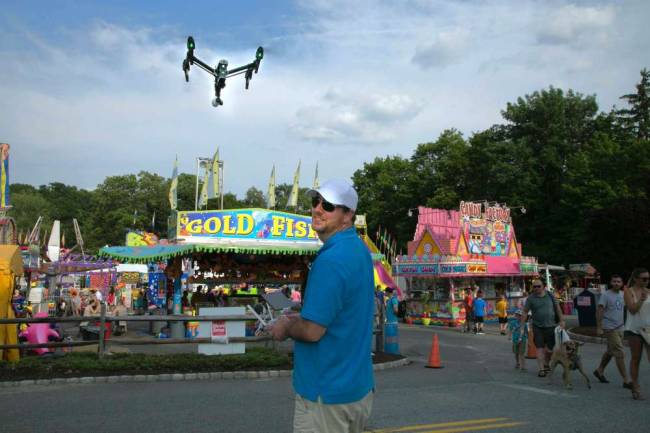
The collective buzz of the octocopter’s tiny rotors was about as loud as a lawn mower.

The camera mounted beneath the small, unmanned aerial vehicle focused on Spencer Valdez, and the copter turned casually and flew above the treeline before returning and hovering in front of him.

Valdez’s fingers were on the controls, but he says one day they might not be.

The co-founder of Franklin-based Snaproll Media believes unmanned aerial vehicles, more commonly known as drones, will change the world in the next 10 years, taking on several jobs once completed by humans in person.

“We are only tapping into a portion of what drones can do,” Valdez said after a drone demonstration on July 11, “just a few of their uses.”

The predictions of the 25-year-old Valdez and his Snaproll co-founder Preston Ryon might not carry much weight if the company they founded in Williamson County six years ago were not now at the forefront of the emerging commercial drone industry.

In September 2014, Snaproll Media LLC became one of the first six companies in the United States to receive an exemption from the Federal Aviation Administration to fly drones for commercial use in public airspace, a strong headstart given that companies like CNN and Amazon only have exemptions to test them.

Just before the demonstration in Franklin, Valdez reclined on a sofa in an unassuming warehouse on Mallory Station Road and discussed the future.

Ryon phoned in from a movie set in Atlanta. The new members of their team, former Oracle executive Steve Brugman and former Hospital Corporation of America executive Robert England sat beside Valdez.

For Valdez and Ryon, 30, they say a unique set of circumstances led them to put a camera on a remote-controlled helicopter when few others were doing it.

“It just made sense”

Brugman, now Snap-roll’s CEO, recalls pulling out a notebook during the first meeting he and England had with Valdez and Ryon and asking them to go over who they had worked for in the past. He said that by the time they finished, he had filled the page with a who’s who list of production companies.

“I was shocked at what these two young men had accomplished in so little time, and at the progression of it,” he said.

Brugman and England were not long ago the new owners of a struggling internet service provider in Nashville, the Nexus Group, where they partnered, remodeled and sold the company to a private equity firm in October 2014.

They heard about the “two young men they should know about” through an accountant in Franklin, and a meeting was arranged in January 2015, where the two founders shared their story.

Valdez and Ryon met at a Lewisburg, Tenn., airport in 2006 and hit it off. For the next three years, they bonded over flying.

Toward the end of that period, Valdez had taken on a photo hobby that earned him extra cash and toyed with remote-controlled helicopters on the side.

“I was taking RC helicopters and building camera mounts for them,” he said. “I was taking video and working on it to make it smoother and more stable.”

Meanwhile, Ryon was a corporate pilot and project manager for a development company. He was taking pictures from the air for developers while he flew over their sites in a full-sized helicopter. When he compared the images he captured with those Valdez took, Ryon said saw an opportunity.

“I realized the cost difference for him to put a camera on a drone,” Ryon said. “I saw that we could do the same thing with a 10-pound helicopter. We could get crowds, do shots of buildings. That was key for me.”

In 2009, they started Snaproll Media LLC.

The gigs came in mainly by word of mouth.

First they were doing real estate, then low-budget music videos, then bigger names — Rodney Atkins, Josh Thompson, Taylor Swift, Tim McGraw.

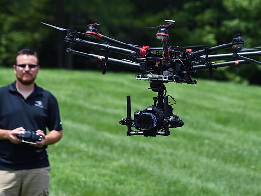
As the jobs got bigger and the equipment fancier, so did the warehouse. Valdez purchased welding equipment and remodeled the drones and camera mounts for more stability.

By the time they had started flying with $20,000 worth of cameras on board, they were in a league of their own.

“We started realizing, ‘We’re the only ones doing this,’ ” Ryon said. “There were maybe two or three other companies flying cameras for a while.”

This led to four years of globetrotting for Valdez and Ryon, jumping from continent to continent for high-profile productions.

“They had this kind of courage to stand up to immense pressure, and I think they had youth to thank for that,” Brugman said.

England agreed.

He recounted that one of their first major productions for a country music video, they flew a $20,000 camera over a lake for an aerial shot of the boat.

“I don’t think they even knew if the camera was insured,” said England, a business partner in Snaproll. “That’s more of a risk than I would have taken.”

The FAA and a changing world

In the years since the advent of affordable drone technology, the do’s and don’ts of personal and commercial use has been a veritable mine field for the Department of Transportation administration tasked with policing the skies.

Stories of drones interfering with law enforcement investigations, crossing paths with police helicopters or other aircraft and invading privacy have become more common. In Southern California, for instance, drones have flown over wildfires and interfered with air tankers battling the blazes. There’s even a $75,000 reward in one county for information on who was behind the drone flights.

But drones offer a compelling alternative for many dangerous jobs.

Brugman said that even in the film industry, Snaproll has replaced cranes as much as helicopters.

“When you think about how you have to risk human life to do some of these jobs, it’s hard not to see they are the way to go,” he said.

In February 2015, the FAA proposed a framework that would allow certain small unmanned aircraft to fly legally, for both personal and commercial uses. The restrictions for personal use were lax and said basically don’t fly over people, into restricted airspace or in areas that may be hazardous.

For those wishing to make money flying drones, the bar is higher. The rules require a pilot-in-command to possess a private pilot certificate and have logged 25 hours flying drones. The rules also mandate an additional visual observer.

In June, FAA Deputy Administrator Michael Whitaker said new rules would likely be finalized in the next year that would open drone use to a broad spectrum of companies, so long as regulations are followed.

http://www.tennessean.com/story/news/2015/08/01/franklin-startup-heart-drone-industrys-cutting-edge/30912757/

Factoryville, PA native gets permission to fly drone for money

mattsch

BRENDAN GIBBONS

A Factoryville native is among the first Pennsylvanians to receive official permission to make money by flying drones.

Matt Sandherr, 33, operating under his fledgling business Diversified Drone, received a notice July 24 confirming he was exempt from certain Federal Aviation Administration regulations that would have stopped him from using his drone for commercial purposes.

Drone pilots have been able to fly their crafts as hobbyists for years, though FAA regulations have prohibited commercial use. The agency proposed new regulations in February that would clear the way for more commercial users. For now, seeking exemptions on a case-by-case basis has become the most common way to fly for money. The FAA granted the first exemption in July 2014 and has issued more than 900 since.

Mr. Sandherr’s application was submitted by Joseph Price of Corbett Price Law, a Scranton attorney trying to build his drone law practice. He submitted about 30 pages describing the drone’s airworthiness and Mr. Sandherr’s piloting ability. The user manuals that came with Mr. Sandherr’s DJI Phantom 2 drone were included in the application, he said.

“The Northeast Pennsylvania corridor is ripe for these kind of exemptions,” Mr. Price said. “(FAA officials) look for low-density populations.”

But Mr. Sandherr plans to explore the promise of drone flight outside Northeast Pennsylvania. He sold his Blakely-based car window tinting business, Mobile Tint Inc. Early this month, he packed up his drone and family and moved to Punta Gorda, Florida, where he hopes to start making promotional videos for charter fishermen and real estate firms, among others.

The drone can provide a new perspective on boating into a canal-front Florida property, he said.

“If you shot a nice drone video, you can, for real estate, demonstrate the trip in from the harbor…from an aerial point of view and share that with hundreds,” he said.

He recently made a video for a Florida friend who captains a fishing boat. It includes several aerial views of the boat cutting its way through brackish mangrove swamps.

“It was an amazing set of shots,” Mr. Sandherr said. “It just really illustrated the boat, the harbor, the set of islands.”

Mr. Sandherr began flying drones about three years ago, but has been interested in piloting since his first trip in a small plane around 10 years old. His first solo flight was one of the most exhilarating and terrifying experiences of his life.

“That’s the most incredible experience in the world, when somebody hops out and says, ‘I’ll be listening in on the radio, but if something goes wrong, it’s you,’” he said.

With its relatively low cost and versatility, the drone offers a new set of opportunities.

“It’s such an amazing piece of technology, the possibilities and the uses,” he said.

Around the country, aerial surveyors for farmers, mining companies and the oil and gas industry have received FAA permission, as have filmmakers and advertisers.

Mr. Price hopes other local drone operators will seek exemptions. He has also submitted an application for Access Aerial, started by University of Scranton systems administrators John Culkin and Lee DeAngelis. Theirs has not yet been granted.

http://thetimes-tribune.com/news/business/factoryville-native-gets-permission-to-fly-drone-for-money-1.1921186

Hobbyking Beer Lift 2015

beerlift2015

It’s that time of the year again… it’s time to lift some beer! You’ve all seen this one before and it’s time to get your entries in. For those who haven’t experienced the HobbyKing Beer Lift it’s simple, the one who lifts the most beer wins. And by wins, we means there’s $2,500 worth of store credits up for grabs.

There are 3 classes: 250, 500 and for those boys who like big toys there’s the Unlimited Class.

And for those who had a go, but failed big time, there’s also $500 up for grabs in Disaster Class. That’s right, $500 in store credits just for owning the biggest failure.

If you don’t win we have loads of MultiStar batteries for the runner ups.

So check out the rules and post your entries here.

RULES

The classes are: (measurements made diagonally from centre of prop hub to prop hub)

250: 250mm and less

500: 251mm to 500mm

Unlimited: 501mm up

Disaster Class: Any sized multirotor that has seen better days

All video submissions must include the following in one take with no editing:

  • – weighing of the beer
  • – measuring of the multirotor
  • – confirmation of battery used

The video must clearly show the weight of the beer cans/bottles prior to flight along with the diameter of the multirotor shown in centimetres. Any video that appears to be edited after the weigh-in will not be accepted. The judge’s decision is final.

The multirotor must be built in 2014-2015 and cannot be a previous entrant in HobbyKing’s 2014 or prior Beer Lifts.

To qualify you must be using MultiStar, Nano-Tech, Nano-Tech A-Spec, Zippy or Turnigy Li-Poly batteries.

The multirotor must be able to lift the payload for at least 10 seconds.

Videos must be uploaded to YouTube and linked to us through our official entry form.

If beer cannot be used, entries using other drinkable liquids will be accepted.

Disaster Class winner is determined on many factors… but mainly what the judges find funniest (bring the lolz).

The maximum store credit prize for Unlimited Class is $1000, 500 Class is $500 and 250 Class is $500. All entries must be submitted before midnight on the 1st October 2015. No entries will be accepted after this time, so get yours in early.

To encourage entrants to get their entries in early the value of each prize will reduce by $50 every week after the 1st September. For example if you get your Unlimited Class entry in on the 31st August and you are the winner, you will receive $1,000. If you are the winner and your entry was submitted on the 7th September you will win $950. From this point the prize will drop $50 every week, so get you entry in early.

http://www.hobbyking.com/hobbyking/store/beerlift.asp?utm_campaign=FDU310715.UK&utm_content=1488784664&utm_medium=email&utm_source=EDM


Daniel Herbert of Rockaway Twp. gets aerial shots with his feet still on the ground

danielherbert

BY SANDRA PLEDGER

Making a business work goes a long way, as Daniel Herbert, a Rockaway Township resident and owner of Skygear Solutions, Inc. would know.

He has been a successful business owner since 2014. Herbert found his way here from Delaware and provided Rockaway Township with a glimpse of what his company is about at White Meadow Lake Festival Days recently.

“It’s been a long time since I felt like I lived in a real community of families all happy to coexist and enjoy a great summer weekend together,” Herbert said. “I am always looking for exposure for my business and I also enjoy providing a new view from the air to those who are uninitiated with this technology, so of course I brought some equipment with me to show off.”

His wife, Marina Kopylova, is his partner in ownership and also operates as chief marketing officer.

Herbert said that having already worked with radio controls as a hobby and with retail and marketing is what made going into this type of industry a natural progression.

He said that multirotor drones have quickly trended into the highest revenue-generating products for both consumer and professional sales.

“This stuff is just plain fun,” Herbert said.

The camera streams live HD video to him on the ground which he can watch while framing shots. It also records the video and photos onto a memory card that he can recover after it lands.

The drone takes video and photographs. Both are very high quality but not usable for “spying” on people. The camera does not have zoom capability and the aircraft is quite loud if it gets up close.

Herbert’s company provides aerial photography and videography services, along with individual and group flight training. They also host several events each year, attend legal panel discussions, security conferences, perform flight demonstrations, have product launches, and provide customer service.

He said that Skygear sells ready-to-fly drones from $29.99 to well over $10,000. They also offer custom solutions that can be specialized for law enforcement, fire companies, agricultural use, cinematography, or even drone racing.

“We believe that with such a new and poorly understood technology that a certain level of after-care is necessary for customer retention and further dissemination of our brand,” Herbert said. “Educating our customers is a priority. Ensuring that safety guidelines are followed as well as maintaining a certain common courtesy to the public is very helpful in preventing unwanted incidents.”

Several events that Skygear Solutions has already done this year include: hosting the Team Delaware leg of International Drone Day with over 300 attendees in March, covering the Newark National Little League season opener and providing aerial footage to the crowds and setting up multiple hands-on displays to hundreds of Little League age boys and girls, and attending the Summit Aviation Community Day in Middletown, Delaware.