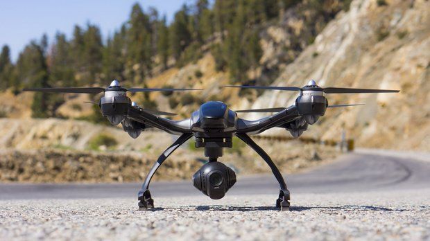
Drone companies flourishing in the Flathead (Montana)

By Seaborn Larson/The Daily Inter Lake

When people spot an unmanned aerial vehicle, more commonly known as a drone, it can be unnerving for some who wonder if they’re under surveillance or what the hovering contraption is doing overhead.

Jeff Scholl predicts that in just a few years, these unmanned aerial vehicles will be such as common as birds flying through the sky.

Scholl, the chief pilot for Gravity Shots, has been working in aerial cinematography since the 1990s. His career has taken him around the world (except Russia) as he has mastered piloting these small, precision aircraft for production companies.

Gravity Shots, located on Montana 40 near Whitefish, is primarily a production company, shooting high-resolution aerial footage for television production companies such as The History Channel, ESPN and Fox News.

“They call me the drone guy,” Scholl said. “I’m a freelancer and sometimes I’m just another crew member on these jobs.”

His wife, Adele, handles the controls of the gimbal, the mechanism that controls the camera angle and stability while the drone is airborne. Adele came to Montana by way of Colorado, having moved for school from Virginia.

“Women are a huge minority in the film industry,” she said. “It’s kind of foreign to show up on set and gain a different respect from the crew and producers. But Montana is the prettiest place we’ve filmed and that’s why we live here.”

Adele is the chief camera operator and video and photograph editor for Gravity Shots. The website lists her as a pilot-in-training as well.

Jeff started Gravity Shots nearly 16 years ago. His father flew F-18s, so he grew up in the aviation community. A cameraman since owning his first Polaroid camera at the age of 9, Scholl wanted to get a better view from up above.

As the modern unmanned aerial vehicle emerged, Scholl was among the pioneers who kept cinematography attached to the product. He said he could remember a time when he could count all the drone production pilots in the country on one hand. In the last two years, he said, the technology has grown exponentially. Several companies send new, sometimes prototype models to Scholl to test before they are released on the market.

“Every time you turn around there’s a new model,” Scholl said while piloting a Freefly Alta model that was released just two weeks ago. “Give it another week, and they’ll probably have made a Chinese knockoff [of this model] somewhere.”

The rise of commercial drones led to a host of federal regulations that define where and at what altitude commercial unmanned aerial vehicles are allowed. These regulations are constantly being amended. Since fall of 2014 drone pilots need to obtain a Section 333 exemption grant, certificate of operation, aircraft registration and airman piloting certificate all with the Federal Aviation Administration before piloting an unmanned aerial vehicle.

Hobbyists don’t require the 333 exemption, but have tighter regulations. They must fly under 400 feet, can’t fly within a 3-mile range of an airport and must keep the aircraft within sight of the pilot.

Commercial pilot restrictions are similar, but they are allowed to fly up to 1,200 feet.

“In the past, it was just the Wild West; no one knew what was going on,” Scholl said. “What they were trying to do was lump this toy helicopter in with full-scale aircraft. But a judge said, ‘if that’s true, then a paper airplane is an aircraft.’

“What happens now is the 333 has become a requirement to work on the job,” he added.

The reason for regulations is airspace.

Scholl said it’s usually the hobbyists who are involved with collisions with airplanes or helicopters. Commercial pilots, he said, don’t have much interest in sending a drone 8,000 feet into the air.

It’s almost standard now, Scholl said, for a production company to have a fully licensed unmanned aerial vehicle pilot on staff. With advancements in design and functionality, Scholl has been able to maintain the work that gets him the bigger jobs. The design has been advancing in the direction of lighter drones, longer battery life and a better stabilization for cameras.

The gimbal is a gyro-stabilizing mechanism that holds the camera beneath the drone. Even while Scholl swings the drone from side to side, the monitor held by Adele shows a smooth camera motion that maintains its focus.

“Before this system it would all be throw-away footage,” he said. “Now it’s smooth and professional; it’s very easy.”

Another strong change in the design is the ability to quickly fold up and move to the next shooting spot. Staying mobile has been Scholl’s goal.

“Most of my stuff is jumping on a snowmobile or four-wheeler,” Scholl said. “The best part about where we operate is we can test things like flight time or how these cameras operate in the cold or heat.”

Recently the Scholls have been contracted to take photographs for local real estate companies.

The company has been contracted for much larger productions such as a commercial that recently brought Scholl to Florida to fly drones between skyscrapers in Miami.

The growing interest in drones has created a retail market for them, even in the Flathead Valley.

Quadrocopter, of which Scholl is a part owner, is a retail company that sells several models of unmanned aerial vehicles, flight training, and multi-rotor upgrade and repairs. The company, which shares space with Gravity shots at the Montana 40 location, was started in 2006 by Adam Paugh and Florian Seeger. Needing a licensed pilot, Quadrocopter owners signed Scholl into the company as its chief pilot in 2010.

Matt Ragan, a pilot for Quadrocopter and his own company, Bird’s Eye of Big Sky, brought his unmanned aerial vehicles to the Northwest Montana Fair to film the rodeo.

Quadrocopter soon will offer its services in Los Angeles and New York, rather than shuttling clients to Kalispell for flight training.

The increasing functionality of drones is emerging every day. Amazon has said it hopes to use drones to deliver items to consumers.

Lifeguards may soon be able to fly a flotation device out to a struggling swimmer via a drone.

“The military probably isn’t going to develop another fighter with a pilot inside,” Scholl said. “Why would they?”

In a year, Scholl believes the 333 exemption will be outdated, as the Federal Aviation Administration may just require some form of piloting experience. For now, Scholl is simply enjoying the ride as the market takes off.

“Plus, it’s just fun,” he said. “Every day is in adventure.”

http://www.dailyinterlake.com/business_and_finance/local_montana/drone-companies-flourishing-in-the-flathead/article_547f76fc-4ea6-11e5-bdf3-4bf2cb1f8e5d.html


FAA Starts Beta Testing App That Tells Drone Pilots Where They Are Allowed To Fly

iPhone-6-3Earlier this year, the Federal Aviation Administration (FAA) announced that it would soon start beta testing an app that would help drone flyers understand where they can and — more importantly — can’t fly. Today, the FAA announced a few more details about the app and launched the first beta version of the aptly named B4UFLY app for iOS.

Sadly, though, this is still a private beta test that will likely run for two months. For now, the app will be iOS-only, with an Android version to follow at an unspecified date.

It looks like the private beta is currently oversubscribed, but you can still get on the waiting list by emailing b4ufly@faa.gov to request an invite.

Judging by the screenshots the FAA posted today, the app is going to be pretty easy to use. The main purpose of the app is to tell you whether you are too close to an airport, in a national park (where drone flights are now forbidden), or another restricted area to fly your drone (or “unmanned aerial vehicle” or “remote controlled quadcopter” if you don’t like the word “drone”).

The app will let you both plan future flights and check whether there’s any issue with your current location. That’s about it — but that’s also all you really need to know.

If you’re within five miles of an airport, you can only fly after you notify the airport operator or talk to air traffic control. Chances are you don’t want to do that, so you better stay out of those areas. The FAA says future versions of the app will include a system for notifying air traffic control of your intent to fly within this five-mile zone.

Because this is such a problem for drone pilots who don’t want to end up in local news reports, a number of services and apps like Hover have sprung up over the last few years that also show drone pilots where they can and can’t fly. DJI’s Phantom drones won’t even take off if they are in some restricted drones. Chances are, though, that an official authoritative app from the FAA will give pilots a lot more confidence than third-party services.

And because it’s that time of the year — remember to never fly your drone close to a wildfire either.


Here’s why Intel can’t stop investing in drone companies

IntelBusiness Insider screenshot of Intel videoIntel CEO Brian Krzanich spies a drone

Intel has got a thing for drones.

The world’s largest chipmaker announced this week that it invested $60 million in a Chinese drone-maker, marking its third drone investment to date.

What’s does Intel see in unmanned aerial vehicles ?

The flying machines are packed with the kinds of sophisticated chips that Intel sells and the popularity of drones makes them an attractive new market for Intel to get a foothold in as its traditional PC business continues to decline.

Processors, WiFi chips and Bluetooth chips can all be used in drones, explains Mike Hung, an analyst with research firm Gartner. Because drones are equipped with technology such as high-definition video cameras for recording, there’s also a role for powerful graphics chips, he explained.

Still, while drones are a sexy market in the emerging “Internet of Things” sector, they won’t drive significant growth for the tech company in the near future, nor will drones replace all of Intel’s lost PC revenue, Hung noted.

“The drone market isn’t going to become as large or profitable as the PC market for another decade, if ever,” Hung told Business Insider. “But it’s got good proof points: it serves large networks the way Facebook is looking at it, [it  can be used for] smart farming purposes, it monitors cell towers, and there’s recreational uses like recording your kid’s softball games. While the drone market isn’t as sizeable as PC or smartphone, its tech can be used for a lot of other purposes.”

According to a CB Insights report conducted earlier in May, drones startups are in vogue: they raised a record breaking $172 million in equity financing so far this year. Commercial usage for drones has been enjoying speedy growth, compounding more than 3 times as much as military use at 19 percent between 2015 to 2020.

Intel has already invested in two other drone companies, Airware and Precisionhawk.

In a video announcing Intel’s latest $60 million investment in Hong Kong-based drone and aerospace company Yuneec, Intel CEO Brian Krzanich said future product collaborations between the two companies will hopefully be a “gamechanger in the drone industry”.

Users will soon be able to open a box containing a little drone, controller and built-in screen. They would be able to fly the unmanned aerial vehicles using Android smartphones, and laypeople would be able to control them within five minutes of unboxing the product.

But while Intel is opening its wallet to show its love for drones, Gartner’s Hung noted that the company is unlikely to ever build and sell its own drone. Intel doesn’t like to sell “end-products” he noted, and will be content providing the innards for the new machines.

Unconfirmed midair between Piper Apache and unidentified RPA

Drone Mid Air Wing1

The unconfirmed report is that a “company survey” aircraft impacted a small UAS at 2,500 feet near Lewis University (KLOT) Illinois on August 27, 2015 causing damage to the leading edge of the manned aircraft wing. The only confirmed RPAS manned aircraft strike occurred in 2011 in Afghanistan.

More as we get it but this is what we know

The manned aircraft was N900AM, a Piper Apache.

N900AM

lewisuni

Looks like it was the tail that was hit to me

Drone Mid Air Wing2

IDENTIFICATION
Date: 27-AUG-15
Time: 16:00:00Z
Regis#: N900AM
Aircraft Make: PIPER
Aircraft Model: PA23
Event Type: Incident
Highest Injury: None
Aircraft Missing:
Damage: Unknown
LOCATION
City: ROMEOVILLE
State: Illinois
Country: United States
DESCRIPTION
Description: AIRCRAFT STRUCK AN UNKNOWN OBJECT WHILE IN FLIGHT, ROMEOVILLE, IL.
INJURY DATA
Total Fatal: 0
Fatal Serious Minor None Unknown
Flight Crew 0 0 0 1 0
Cabin Crew 0 0 0 0 0
Passenger 0 0 0 0 0
Ground 0 0 0 0 0
OTHER
Activity: Personal
Flight Phase: EN ROUTE (ENR)
Operation: 91
Aircraft Operator:
Flight Number:
FAA FSDO: FAA W. Chicago-DuPage (NON Part 121) FSDO-03
Entry Date: 28-AUG-15
Updated since entry: No

http://www.asias.faa.gov/pls/apex/f?p=100:96:::::P96_ENTRY_DATE,P96_MAKE_NAME,P96_FATAL_FLG:28-AUG-15,PIPER

That C130 in Afghanistan

Feds approve paper airplane drone flights

powerup3.0_2_grande

By Keith Laing

The Federal Aviation Administration (FAA) has approved the use of a paper airplane that is a drone.

The agency issued the approval for flights of a drone that is described as a “smartphone-controlled paper airplane.” In doing so, it waived requirements for FAA approval of drone flights that are operated outside of restricted airspace and below 200 feet.

The agency said the flights were approved for “aerial photography and videography” purposes.

The makers of the paper airplane drone, Connecticut-based Tailor Toys PowerUp, tout the paper airplane drones as a revolutionary product.

“The PowerUp 3.0 transforms ordinary paper planes into smartphone-controlled flying machines,” the company says about the devices on its website.

“Simply tilt your smartphone or tablet to maneuver right or left and use PowerUp’s throttle lever to ascend or descend,” the description continues. “The motorized frame’s 180 feet/ 55 meter range, crash­-resistant design, and responsive motion control and precision turning give users extremely flexible flight control.”

The FAA has approved more than 1,000 drone flights in the process of developing regulations for allowing a rapid expansion of the use of the devices in the U.S.

The agency has faced tremendous pressure to approve an expansion of nonmilitary drone use from companies such as Amazon, which has said the technology can be used to make speedier online deliveries.

Police and other law enforcement groups were also seeking approval to use the technology, and the FAA has investigated several drone incidents that occurred in conjunction with photography at college and professional sporting events.

The section of law that allows the FAA to grant drone exemptions gives the Transportation Department the authority to drop a requirement that operators of the technology apply for a certificate of airworthiness that is normally required for flights that are formally considered an aircraft.

In its letter to the paper airplane drone petitioner, Connecticut resident Peter Sachs, the FAA said it “has determined that good cause exists for not publishing a summary of the petition in the Federal Register because the requested exemption would not set a precedent, and any delay in acting on this petition would be detrimental to the petitioner.’

The definition of drones as aircraft under the FAA’s proposed rules has riled recreational operators of the devices who consider themselves hobbyists instead of pilots.

The FAA’s rules define small drones as devices that weigh less than 55 pounds and require them to be operated at heights that are less than 500 feet and speeds that are less than 100 miles per hour.

The regulations also call for drone flights to be limited to daytime hours and conducted only by U.S. residents who are older than 17.

Drone operators are also prohibited under the FAA proposal from conducting flights that take the devices out of their line of vision — a big blow to companies like Amazon that have touted the possibility of using the technology to conduct deliveries.

http://thehill.com/policy/transportation/252141-feds-approve-paper-airplane-drone-flights

Drone’s crash-landing on Lexington’s tallest building prompts concern

rooftopphantom

Richard Moloney

LEXINGTON, Ky. (WKYT) – At-Large Urban County Councilman Richard Moloney said he was surprised to learn that a drone crash-landed on top of the Fifth Third building this weekend. However, Moloney said he was more concerned about the drone’s proximity to the Blue Grass Airport, about 6 miles away from downtown.

Moloney says he plans to form a committee to education people on drones — what is and what isn’t allowed.

“I think it’s an issue,” said Moloney, who has been a pushing education of drone use. “The number of drones have gone way up and being that close to the airport and being on the airport board I have concern.”

Downtown Lexington’s Fifth Third Bank building stands over 400 feet tall, the maximum height for unmanned drones.

The drone crash-landed on top of the building around mid-day Saturday.

Workers say the drone operator went inside the Fifth Third building and asked security if he could go up to the roof to get his drone. He wasn’t allowed to do so.

The building’s security immediately called the Federal Aviation Administration, the national aviation authority, and alerted them to what happened.

A spokeswoman with the FAA confirmed the report that an unmanned aircraft crashed on the roof of a building at 250 West Main Street. The FAA contacted the operator, and provided him with information about requirements for safely operating unmanned aircraft.

Chris Stiles is the President of Unmanned Services, Inc.- a drone flight services company.

“The FAA has so many regulations that affect manned aircrafts, the books are really thick. The aviation regulations, some of them still apply to us. We still have to know and fly according to that and then some things we’re exempt from- some things where there’s stricter mandates put on it. It’s figuring out and knowing all the things. It takes a lot of work. It takes a lot of knowledge,” Stiles said.

http://www.wkyt.com/home/headlines/Lexington-councilman-to-push-education-for-drones-323145761.html

Chuck Schumer’s No-Fly-Zone Rule for Drones Won’t Work

U.S. lawmakers and the military worry about small consumer drones running afoul of planes and emergency crews. But there may be no simple fix.
By Patrick Tucker, Defense One

Senator Chuck Schumer speaks at New York University, August 11, 2015.(Andrew Burton/Getty Images)

August 25, 2015 Small consumer drones have become the plague that Moses missed. So far this year, 650 drones have been spotted by airline pilots. That’s on pace to quadruple last year’s total, which is troubling because if a pilot can see your drone in the air, it’s close enough to worry about. In July, a wildfire in California consumed 20 vehicles on a highway north of Los Angeles when consumer drones interfered with firefighters for the fifth time that month. And testing jet engines against consumer drones has proved to be a challenge.

To answer this growing problem, Sen. Chuck Schumer last week proposed an amendment that would require consumer drone manufacturers to build software-controlled no-go zones—so-called geofences—into their aircraft. The idea is to let software keep them away from airliners, emergency crews, and the like. “This technology works and will effectively ‘fence off’ drones from sensitive areas like airports,” Schumer said in a press release. Two recent hacker demonstrations show that’s somewhat wishful thinking.

What is a geofence? It’s manufacturer-created software that prevents a drone from flying within certain GPS coordinates. Some drones already come with it; after an intoxicated General Services Administration employee crashed a friend’s DJI Phantom on the White House lawn in January, DJI issued a mandatory upgrade to its software: a geofence that prevents the popular toys from flying within 25 kilometers of the White House and other sensitive sites.

Schumer’s bill proceeds from the notion that such measures can keep drones out of trouble. But while geofences may help keep the average hobbyist away from the White House, hackers have already shown they can rip holes in them.
Earlier this month, researchers at the DEF CON hacker conference in Las Vegas, Nevada, demonstrated that the Phantom’s geofencing was easily manipulated in a variety of ways. Cybersecurity researcher Michael Robinson showed that the DJI Phantom III’s geofence draws upon a database that contained some 10,914 entries as of July 24. Each entry contains a country, city, a timestamp, and, more importantly, the latitude and the longitude of the no-fly zones, according to Robinson’s research.
“I very easily downloaded the database and started just changing entries, which I found very interesting,” he said.

Earlier this month, researchers at the DEF CON hacker conference in Las Vegas, Nevada, demonstrated that the Phantom’s geofencing was easily manipulated in a variety of ways. Cybersecurity researcher Michael Robinson showed that the DJI Phantom III’s geofence draws upon a database that contained some 10,914 entries as of July 24. Each entry contains a country, city, a time stamp, and, more importantly, the latitude and the longitude of the no-fly zones, according to Robinson’s research.

“I very easily downloaded the database and started just changing entries, which I found very interesting,” he said.

By tweaking the data, Robinson was able to make his Phantom ignore the manufacturer-set no-fly zones.

He said he also used a garage-made GPS spoofer to disrupt the geofence. He reported that the spoofer broke the drone’s return-home feature and compromised the video feed, which he described as suddenly “squirrely.”

Two other researchers, Lin Huang and Qing Yang, with the Internet security company Qihoo 360  out of China, also reported being able to disrupt a Phantom’s geofence by spoofing the drone’s GPS remotely, via software-defined radio. This is far more troubling because they didn’t need to have physical access to the machine, just be within range. But such results are harder to verify by independent American researchers because GPS spoofing is very, very illegal.

Perhaps more damning, the hackers demonstrated these tricks on products that the makers had actually undertaken some effort to secure. Phantoms use secure radio and GPS for guidance rather than the less secure WiFi or Telnet.

Defense One reached out to DJI Phantom for comment and has not heard back.

What does Robinson think of legislative efforts like Schumer’s? “With respect to policymakers, I would like to see policymakers get informed,” he said.

If the government can’t ward off drones using manufacturer-based geofences, what then? Don’t look to traditional military-grade air-defense systems, which are built to spot far larger and faster intruders. On April 15, a 61-year-old man named Doug Hughes took off from Gettysburg, Pennsylvania, in a homemade gyrocopter and flew through three no-fly zones to the steps of the U.S. Capitol. “Identifying low-altitude and slow-speed aerial vehicles from other objects is a technical and operational challenge,” Navy Adm. William Gortney, commander of U.S. Northern Command and North American Aerospace Defense Command, or NORAD, later told the House Committee on Oversight and Government Reform.

Still, the Federal Aviation Administration, the Homeland Security Department, and the military are giving it their best shot. On Sunday, NORAD staged an exercise near Washington, D.C., to test its ability to detect and intercept drones.

Last year, the military held the 10th edition of its Black Dart exercise, which focuses specifically on anti-drone defense. In recent Black Dart games, the military has focused more attention on so-called Group 1 drones: consumer quadrcopters and others under 20 pounds, like the one that crashed on the White House lawn, or the one that landed on the roof of the Japanese prime minister’s residence carrying a small amount of radioactive material back in April.


How do you differentiate between a 10-year-old kid who just doesn’t know any better and is flying something from a hobby shop and somebody who’s flying that identical something from a hobby shop but has nefarious intent?” said Air Force Maj. Scott Gregg. “You can’t tell that with a radar or an infrared sensor.”

Even if it’s possible to detect small drones like the DJI Phantom or the popular (and very hackable) Parrot BeBop as they move into sensitive areas, a bigger problem is taking them down in a way that doesn’t interfere with GPS or other electronic-signaling.

The defense industry wants in to the growing market of detecting and downing those diabolical drones. Scientific Research Corporation, or SRC, is marketing a set of systems they call “Counter UAS Technology.” Aimed at consumer-sized unmanned aerial vehicles, it uses radar and electromagnetic frequencies to down drones around a protected facility. “You’re going to be looking at acoustic sensors for very close. You’re going to be looking for electromagnetic warfare capabilities,” said Tom Wilson, SRC’s vice president of product accounts, who declined to get more specific about the system’s workings.

A company called Drone Shield also sells several acoustic sensors meant to detect drones near airports. But detecting and signal-jamming are very different, and the later presents serious legal hurdles. Drone Shield will sell you “a legal, safe, and reliable” drone net gun.

In the end, the best defense against small drones may lie somewhere between relying on manufacturer software updates (ineffective) and shooting them down (dangerous and uncouth). SRC’s Wilson said, “Our system is designed to operate without interfering with nonthreat systems.”

Failing that: Net gun, anyone?


http://cdn.defenseone.com/defenseone/interstitial.html?v=2.1.1&rf=http%3A%2F%2Fwww.defenseone.com%2Ftechnology%2F2015%2F08%2Fchuck-schumer-no-fly-zone-drones%2F119389%2F%3Foref%3Dd-river

Update: Intel invests $60 million in Chinese drone maker Yuneec

Yunnec

Intel has poured more than $60 million into Yuneec International Co., a Shanghai-based drone and aerospace company, as a broad range of technology companies investigate the possible commercial uses of unmanned aircraft.

Venture capitalists and companies are investing in drone technology on the expectation that unmanned aerial vehicles will prove beneficial for consumers and industrial customers. Amazon.com and Google are developing drones to deliver products to consumers. Yuneec’s Chinese rival SZ DJI Technology Co. raised $75 million from Accel Partners in May.


“At Intel we believe in a smart and connected world. And one of the best ways to bring that smart and connected world to everyone and everywhere has been drones,” Intel Chief Executive Officer Brian Krzanich said in a video announcing the investment by Intel Capital. “We’ve got drones on our road map that are going to truly change the world and revolutionize the drone industry.”Intel and Yuneec will work on developing future products, the companies said Wednesday. Yuneec makes drones for consumers and industrial users, as well as manned electric aircraft. Intel declined to provide further details on the collaboration. The Santa Clara, California-based semiconductor company has also invested in drone companies Airware and PrecisionHawk.

The Yuneec relationship fits with Intel’s strategy to make investments in companies developing products with the potential to expand the market for semiconductors, as the company searches for new devices for chips. Intel’s drone funding is similar to its investments in next-generation data center software companies such as Mirantis and Cloudera.

– Bloomberg News

http://www.oregonlive.com/silicon-forest/index.ssf/2015/08/intel_invests_60_million_in_ch.html