For those of us who use Yuneec products this is great news.
For those of us who use Yuneec products this is great news.
Aerosense drone
A drone developed by Sony’s unmanned aerial vehicle venture Aerosense is seen in a promo image. The startup wil target enterprise users in everything from farming to construction from 2016. Credit: Aerosense
Equipped with a high-speed data transfer module, the quadcopter uses Sony’s lens-style camera to image construction sites and farms.
By Tim Hornyak
IDG News Service | Aug 24, 2015
Sony is gunning for a slice of the growing drone market, showing off newly developed unmanned aerial vehicles (UAVs) from its just-launched drone venture, Aerosense.
In addition to the vertical takeoff and landing (VTOL) craft hinted at last month, Aerosense on Monday exhibited a quadcopter that makes use of Sony’s lens-type camera, the QX30.
The camera, which resembles a lens for a digital single-lens reflex (DSLR) camera and can link to smartphones, is attached to the belly of the quadcopter, where it can take high-resolution images.
Designed for use in urban areas such as construction zones, the AS-MC01-P quadcopter weighs about 3 kilograms (6.6 pounds) and can fly for about 15 to 20 minutes on a battery charge.
It can operate autonomously, flying within a preset zone, and is equipped with GPS, Wi-Fi and an inertial navigation system. It also has a high-speed data transfer module that uses Sony’s TransferJet technology.
In a presentation in Tokyo, Aerosense showed how photography from the camera can be turned into 3D imagery, showing, for instance, the volumes of piles of gravel at a construction site.
The venture’s other craft, the AS-DT01-E winged VTOL drone, has a rotor system that allows it to fly like a helicopter or a plane. The advantage of the winged format is that it can fly at much higher speeds than most non-military drones — up to 170 kilometers per hour (106 miles/hour) compared to high-speed quadcopters that fly at 75 kph (47 mph).
Weighing 7kg (15 pounds), it can carry a 3kg payload (6.6 pounds) and operate for at least two hours on a battery charge.
Aerosense will target enterprise customers when it begins to offer drones for monitoring, surveying and inspection next year.
Potential applications include photographing agricultural land, mining sites and mountainous areas to check for damage after a storm.
Sony wants to use its smartphone technologies such as cameras and networking know-how to give Aerosense an edge. Sony Mobile Communications owns just over 50% of the venture, with the rest in the hands of Tokyo robotics firm ZMP, which set up a robot taxi company earlier this year along with mobile gaming giant DeNA.
Sony also has robotics resources that it is putting into the drone business. Aerosense’s CTO is Kotaro Sabe, who worked on the electronics maker’s Aibo robot dog and Qrio humanoid robot, both of which were shelved when Sony shut down its entertainment robot business about 10 years ago.
Sony’s Xperia smartphones have been struggling in Japan and overseas against the more popular Apple iPhone as well as Android rivals.
“It’s possible that future growth in smartphones could be limited, so we have to engage and invest in new business opportunities,” said Hiroki Totoki, head of Sony Mobile Communications.
http://www.computerworld.com/article/2975016/emerging-technology/sonys-quadcopter-takes-its-smartphone-tech-to-the-skies.html
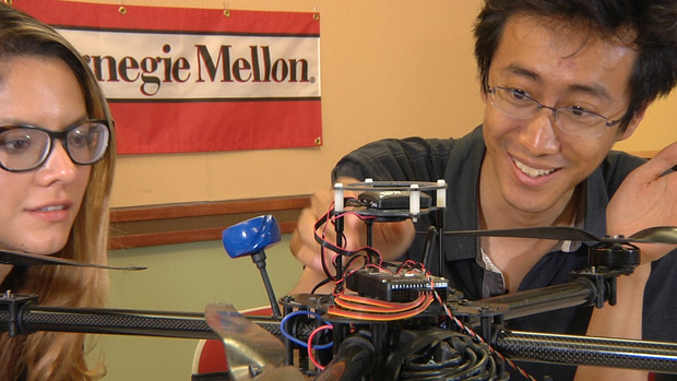
Researchers at Carnegie Mellon University are working on a new generation of disaster drones that can be deployed in swarms into buildings to give first responders a look inside, mapping out the interior as they go.
The drones could be valuable in situations such as those faced recently after massive explosions ripped through a port in Tianjin, China, or in the aftermath of something smaller like a house fire.
“These places are very dangerous for rescuers to go, so we don’t want to just blindly send people inside,” said Pei Zhang, an associate research professor at CMU’s campus inside the NASA Ames Research Park in Moffett Field, California, where the research is taking place.
“Instead, we want to get these things in before people go in and determine if there are people that need help,” he said, gesturing to several drones on the table in front of him.
Zhang envisages using a larger drone, which he likens to a mothership, to carry multiple smaller drones into whatever environment is being explored. The smaller drones would deploy from the large drone and begin their work.
The larger drone, he reasons, has a longer range and can better handle wind and other effects of the environment. But it may be too large to send inside somewhere like a building that’s been compromised by an earthquake.
So the smaller drones, some of which can easily fit in the palm of a hand, would fly inside to do their work.
AUGUST 25–A grand jury today indicted a New Jersey man on two felony charges for allegedly firing a shotgun at a hobbyist’s drone as it hovered near his residence last year.
Russell Percenti, 33, is facing criminal mischief and possession of a firearm for an unlawful purpose charges. The latter count carries a maximum of ten years in prison, while Percenti could face up to 18 months on the lesser felony rap.
Percenti, pictured at right, was arrested last September after Leonard Helbig reported that someone “shot his drone out of the air with a shotgun while he was taking pictures of a friend’s property that is under construction.”
A subsequent police investigation determined that Percenti, a restaurant employee, shot at the drone while it flew near his family’s residence in Cape May County at New Jersey’s southern tip.
As seen in the above photo shot by Helbig’s drone, his friend’s property abuts the Percenti residence, which has an above-ground pool and a rear deck. It is unclear whether Percenti is the individual seen standing on the deck in the below drone photo
Helbig told TSG that the $1300 drone was about 100 feet above the ground when it was fired upon. Helbig, who operates Cape May Miniature Golf, estimated that five shots were fired at the drone, which he said was “destroyed” by the shotgun blasts.
http://www.thesmokinggun.com/documents/crime/new-jersey-drone-shooting-case-213450
By Will Knight
For some construction workers, any thoughts of slacking off could soon seem rather quaint. The drones will almost certainly notice.
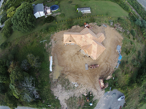
The workers building a lavish new downtown stadium for the Sacramento Kings in California are being monitored by aerial drones and software that can automatically flag slow progress.
Once per day, several drones automatically patrol the Sacramento work site, collecting video footage. That footage is then converted into a three-dimensional picture of the site, which is fed into software that compares it to computerized architectural plans as well as a the construction work plan showing when each element should be finished. The software can show managers how the project is progressing, and can automatically highlight parts that may be falling behind schedule.
“We highlight at-risk locations on a site, where the probability of having an issue is really high,” says Mani Golparvar-Fard, an assistant professor in the department of civil engineering at the University of Illinois, who developed the software with several colleagues. It can show, for example, that a particular structural element is behind schedule, perhaps because materials have not yet arrived. “We can understand why deviations are happening, and we can see where efficiency improvements are made,” Golparvar-Fard says.
The project highlights the way new technologies allow manual work to be monitored and scrutinized, and it comes as productivity in other areas of work, including many white collar jobs, is being tracked more closely using desktop and smartphone software.
http://www.technologyreview.com/news/540836/new-boss-on-construction-sites-is-a-drone/

Photo by Faine Greenwood

The eight-armed drone proceeds along the busy tourist road that leads up to the world-famous Machu Picchu archaeological site in Peru, floating just above the tropical forest that lines each side of the roadway. It’s piloted by Peruvian Ministry of Culture drone expert Aldo Watanave, who watches the device intently, his eyes occasionally darting to the little video screen that I’ve agreed to hold for him.
Another colleague is in control of the camera mounted to the drone’s underside, and he uses a remote control to snap a photo whenever Watanave tells him to. Just up the trail, a middle-aged French tourist with a walking stick comes into view, and he’s not happy to see the drone: He begins swearing profusely, as if we have personally violated him. “From the Ministry of Culture!” I shout back, attempting to gauge how crazy he is.
Drone archaeology is not without its occupational hazards, but for Watanave and his colleagues, the risks are more than worth it. With their drone mapping work, they’re demonstrating to archeologists and museums around the world how they can use aerial imagery to create inexpensive maps and 3-D models of humanity’s collective cultural heritage—virtual representations that may define the museums of the not-so-distant future.
Founded in 2013 by Luis Jaime Castillo Butters, the former deputy minister of cultural heritage and cultural industries, Peru’s drone archaeology team has quickly become one of the most active in the world, working to accurately survey and preserve the South American nation’s thousands of valuable archaeological sites. At the beginning, team members had no special engineering expertise or any prior experience with unmanned aerial vehicles, or UAVs. But in just two years, they have become an authority on this specific area of drone mapping, with archaeologists and drone pilots from around the world now reaching out to them for advice. “Anybody can do the work we do. Anybody can work with the drones, anybody can work with the software, anybody can produce the stuff we are producing,” Castillo explains. “We are simply doing it on a scale that is actually having a real impact on cultural patrimony.”
Since the program began, the Ministry of Culture’s drone team has mapped more than 600 sites, allowing it to create standardized records of archaeological data at a much faster pace than was possible in the days of ground-based surveying. The group has developed a relatively standardized process for its archaeological missions, primarily using Chinese drone maker DJI’s Spreading Wing S1000 “octocopters” for their mapping projects. The hefty drones are equipped with Sony NEX-7 mirrorless cameras and can stay in the air for roughly 15 minutes, but their battery life decreases when flying at a high altitude, as is often the case in Peru.
The drone team’s process begins with marking out at least three ground-control points in the area to be mapped, which can be identified from the sky with the assistance of a highly visible marker. Next, the archaeologists use a differential GPS unit to accurately survey (asses the location of) each point. The drone team assesses the weather—and also makes sure that any people on the ground are aware of what’s happening. When the all-clear is given, it’s time for liftoff.

Photo by Faine Greenwood
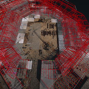
In simplest terms, aerial maps are made by combining hundreds of different photos—I wrote about this process in detail in New America’s new Drones and Aerial Observation primer. (New America is a partner with Slate and Arizona State in Future Tense.) To make sure the photos overlap enough, the drone has to fly in a specific pattern—it’s easy to think of this as the pattern a lawnmower makes as it traverses the lawn, with straight lines overlapping to ensure no spots are missed. Although many drone mappers program their devices to fly themselves in a predetermined pattern, Watanave is wary of automatic drone flight, thanks to the painful memory of a recent drone crash caused by a failed autopilot. Instead, the Peruvian pilots eyeball the pattern and fly it themselves at an altitude between 196 and 262 feet, shooting a photograph every 2 to 3 seconds.
Once shooting is over, it’s time for the archaeologists to use Agisoft Photoscan photogrammetry software to stitch the photographs together into a single image. The aerial maps and 3-D models that archaeologists use have to be geographically accurate—applicable to the real world and capable of being layered on top of pre-existing maps—so the software geometrically corrects (orthorectifies) the images so that they have a uniform scale.
The process may be relatively straightforward, but fieldwork has its own perils, from angry French tourists to technical error to simple poor luck. The $3,300 octocopters are relatively sturdy, but they’re definitely breakable. Not that this vulnerability stops the archaeologists: During my visit to Peru, I watched, impressed, as the team floated the drone (packed in a waterproof case) from the shore of an inflatable raft onto the rocky coast of an island somewhere off the coast near Lima. Two archaeologists walked the hefty box and its robotic cargo up the steep path to the top of the island they’d been sent to survey in punishing heat, as vultures watched their progress.
http://www.slate.com/articles/technology/future_tense/2015/08/how_peru_is_using_drones_to_protect_machu_picchu_and_other_archaeological.html
I have become a bit hesitant to tell people that I work with drones, despite the fact that I love working with this wonderful new technology. Almost every time I tell someone they say, “Oh, those are used for spying, right?” and I have to resist the urge to say something snarky about how unfounded that notion of unmanned technology is.
My understanding is that the majority of people have unrealistic expectations about privacy to begin with. Did you know that it’s legal for a person to photograph another person in their own home without their consent, and then sell those photos in a public gallery? Most people don’t know that, as evidenced by the man who is now facing felony destruction of property charges for shooting his neighbor’s drone down.
As if it’s not bad enough that hackers will steal your information, when companies like Facebook “help” a social movement by facilitating thousands of people putting a rainbow filter over their profile picture the are really studying you as social trend data. You are nothing but a data commodity to these people, and they own your activity to whatever extent it benefits them.Did you even consent to being such a hot commodity?
While there is still something to be said for respecting physical privacy, the more serious privacy concern should be about data aggregation that is tethered to our identity. Practically, there isn’t really a lot you can do with a photo except look at it, which isn’t that damaging; it wont ruin your credit or reveal your web history. In the age of computer technology infiltrating every aspect of life, people need to reshape the way they think about privacy.
Between the amount of information that is constantly being gathered and the power of computing programs these days, I would think people would be more worried that their personal information, habits and preferences are being tracked, analyzed, and monetized, because it seems like there is a new data breach in the news every day. People with drones hardly seem like much of a privacy concern in comparison, right?
http://www.suasnews.com/2015/08/38028/its-the-end-of-privacy-as-we-know-it/
by Lorien Olive and Orlando de Guzman
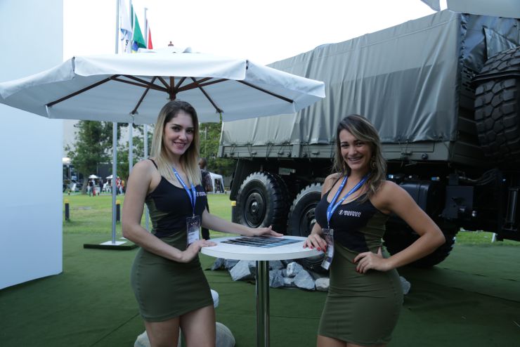
Felipe Castro da Silva, an engineer and UAV coordinator with AEL Sistemas, slipped on a black sports jacket as we began our interview. He was talking about the Hermes 900 unmanned aerial vehicle—a UAV or, in more common terminology, drone. A young man with salt and pepper hair, Castro was in Rio de Janeiro’s sprawling RioCentro Mall to dazzle the 40,000 of attendees of the Latin American Aero and Defense Exhibition with details of of Brazil’s newest medium-altitude, long-endurance (MALE) drone. We were next.
“This UAV,” he said, “patrolled the Maracanã Stadium during the 2014 World Cup and will be used again during the 2016 Olympics.” Able to fly for 30 hours uninterrupted, the Hermes 900 can reach altitudes of up to 30,000 feet and is used mainly for surveillance, reconnaissance, and communications relay. From the ground, it is nearly undetectable, he said.
During the World Cup, Castro added, the drone was fitted with a Sky Eye sensor, whose 17 cameras allow security personnel on the ground to track activity in an area of 100 square kilometers. It also has high resolution sensors, able to identify license plates and even faces at 30,000 feet. In terms of its capabilities, the Hermes 900 is comparable to its more notorious American counterpart, the MQ-1 Predator drone.
AEL Sistemas, based in Porto Alegre, became a subsidiary of the Israeli company Elbit in 2001, at which time it began developing a new generation of Brazilian surveillance drones using Israeli technology. But the Hermes 900 was just one example of Brazil’s growing role in the booming global market for unmanned aerial systems. The LAAD expo’s interior was filled with them.
Read more… http://fusion.net/story/187490/brazil-drone-laad-conference/