FAA releases UAS safety app

By Ann Bailey | September 01, 2015
  • FAA has released an app that the agency hopes hobby UAV operators will open before they fly.
    PHOTO: UAS MAGAZINE

The Federal Aviation Administration (FAA) hopes that unmanned aerial vehicle users will check its app before they fly.

The FAA has released for testing the beta version of B4UFLY. The app is a way to help the operators know whether or not there is a conflict in the air space in which they plan to fly, the FAA said. The beta test will run at least 60 days.

One thousand UAV users received the B4UFLY APP which primarily is for model aircraft enthusiasts. The app is unavailable in the beta version in the Apple store, but the FAA is maintaining a waiting list in case the 1,000 users do not download B4UFLY. People who want to be added to the waiting list should email b4ufly@faa.gov, the FAA said.

The FAA hopes that by using B4UFLY, conflicts between manned and unmanned aircrafts will be reduced. The agency is concerned about the increase of reports of unsafe operations of unmanned aircraft near airports, over people and near manned aircraft.

Although, B4UFLY is targeted at hobby or recreational UAV pilots, the FAA believes that civil and commercial operators will find aspects of B4UFLY useful.

The app uses a location services feature of users’ smart phones to determine whether restrictions or requirements are in effect where they want to fly and gives users a clear status icon. The status indicator functions considers factors such as airspace, proximity to air ports and temporary flight restrictions.

Some other notable features of the App are:

–          Informative, interactive maps with filtering options.

–          Information on the parameters that drive the status indicator.

–          Links to other FAA UAS resources and regulatory information.

The app will allow the model airplane pilots to have access to the information, provided they have a cell phone signal. B4UFLY obtains the information from public data sources and packages it so it is user friendly, the FAA said.

The agency plans to release a full version of B4UFLY to the general public before the end of this year. The beta test is only for IOS devices, but the FAA is working to ensure the full version also will be compatible with Android devices.

http://www.uasmagazine.com/articles/1225/faa-releases-uas-safety-app

CA: Poway votes 4-1 to ban drone operations

poway

BY 

POWAY, Calif. — In a 4-to-1 vote Tuesday night, the Poway City Council approved a 45-day interim ordinance, banning the flight of drones over 75 percent of land in Poway.

Originally, a proposed ordinance brought on by Poway Mayor Steve Vaus was meant to prohibit the flying of drones over local emergencies. He voiced concern that drones would interfere with first responders and in turn put the community at risk by delaying their efforts.

On Aug. 18, Vaus detailed his proposal before the Poway City Council and the city attorney. He wanted to ban drones from flying within two miles of emergencies. Consequences for those caught included a $1,000 fine and the confiscation of the drone.

The Poway City Attorney was given two weeks to write the ordinance ahead of Tuesday night’s city council meeting. The verbiage had been revised to include the banning of the operation of drones over Poway’s urban wildfire interface area, which makes up 75 percent of the city.

Vaus assured the city council that law enforcement would use discretion before applying the law to drone operators, saying the 45 days the ordinance is in effect, would buy them some time to research and perhaps revise the copy.

Some residents voiced their concerns that the law was too ambiguous and the city was too far ahead of themselves.

Tom Moore, a resident of Poway, suggested the city council let the FAA regulate drone use, instead of taking matters into their own hands.

Also redefined in the ordinance were the consequences drone operators faced if they were found breaking the law. They could still face up to a $1,000 fine, but could also face up to 6 months in jail. There is no mention of the drone being confiscated by law enforcement.

After the 45 days is up, the city attorney can present a revised copy of the ordinance after the proper research is completed. A public hearing would be held and another vote would take place.

About a month ago, the flying of personal drones hampered the firefighting efforts of K’s Sandwiches in Linda Vista. Several drones also interfered with Cal Fire’s efforts in the large North fire burning at the Cajon Pass along Interstate 15 in July.

http://fox5sandiego.com/2015/09/01/4-1-vote-by-poway-city-council-to-ban-drone-operations/

Unruly drones spook pilots while entrepreneurs seek to get airborne

belindaandterry

By Ian Duncan The Baltimore Sun

Federal aviation officials are looking to police in Maryland to help deal with a new kind of lawbreaker: drone pilots.

Following complaints from pilots about unmanned aircraft, the Federal Aviation Administration has referred more than a half-dozen cases to law enforcement agencies in the state over the past 18 months, federal records show. That pace is likely to pick up, as pilots are reporting more sightings and near-misses with aircraft.

“Safety’s our first priority,” said Carmine Gallo, the director of the FAA region that stretches from New York to Virginia. “Our responsibility is outreach, education and — if necessary — education again and enforcement.”

In recent weeks, drones have grabbed headlines for near-misses with aircraft — and other potentially unlawful activity.

Last week, for example, Western Maryland authorities arrested two men who were suspected of planning to use a drone to smuggle contraband into a state prison. Attempted drone deliveries of contraband have also been reported in Ohio and South Carolina.

There have been a number of cases of small four-rotor helicopters known as quadcopters having close encounters with other aircraft. In early August, a jet crew reported a small drone within 20 feet of their aircraft as they flew over New York; two days later a helicopter pilot filed a similar report.

But even people who might think they’re using a drone innocently can be breaking the law.

The commercial use of drones must be approved on a case-by-case basis, and just 1,000 companies nationwide have received the go ahead from the FAA. Hobbyists with a $1,000 craft ready to go out of the box can fly it — as long as they follow some basic rules.

The problem, aviation officials and researchers say, is they often don’t know what those rules are.

“I don’t think there are people that are out there saying, ‘I’m trying to cause a major aviation disaster,’” said Jon Greene, a retired Navy officer who works on drone research at Virginia Tech. “I think there are people who just don’t understand what the risk is. Those things flying in the wrong place at the wrong time can take down a general aviation aircraft and can be ingested into an engine of a commercial airline, and that can be really, really bad.”

The FAA says pilots have seen a surge in the number of drones in the skies, filing more than 650 reports of sightings this year by early August. They reported only 238 sightings in all of 2014.

Agency records show a number of incidents in Maryland, including one last year in which a pilot reported a quadcopter approaching his plane soon after he took off near Annapolis. “Pilot stated that was a very unsafe situation,” the report reads, though there is no indication an investigation was launched.

Government officials are trying to warn would-be drone users about the risks and the rules. Earlier this year, the U.S. Department of Agriculture issued an image in the style of a World War II propaganda poster warning drone pilots that if their devices are in the air, emergency crews battling wildfires will be grounded.

On Friday, the FAA released a test version of a iPhone app called B4UFLY to 1,000 drone users. The tool indicates whether it’s legal to fly in a particular location, cutting through the layers of rules that govern American airspace.

Although the FAA is trying to work with local police, two departments in Maryland that FAA records indicate got a complaint about drones said they had no record of any investigation. The FAA can carry out civil investigations and levy fines on its own, and it has filed about 20 cases, spokesman Les Dorr said. It has reached settlements in five cases and has proposed penalties in another five, he said.

While pilots continue to get spooked by errant drones, entrepreneurs and researchers complain that they face overly restrictive limits on their aircraft, even though they have more incentive to fly safely.

Terry Kilby has been developing drones for a few years, ever since he bought a device that let him print out parts to make his own unmanned aircraft. As he progressed, he started ripping apart Nintendo Wii remotes and pressing the sophisticated technology into service. He also tested his skills on flight simulators to avoid costly crashes.

“When we were first starting, it took a lot of practice,” Kilby said.

Now he’s trying to develop a successful aerial photography and digital mapping business. He quit a lucrative engineering job this year to work full time in building and using drones.

More http://www.baltimoresun.com/news/maryland/bs-md-drone-safety-20150829-story.html

Who’ll keep track of all those drones in flight?

Drone traffic control systems mature

With the increased proliferation of smaller aircraft, or hobby drones, that are capable of flying under traditional radar, more unmanned aerial systems will be crowding the skies — and existing air traffic control systems won’t be able to track them.  NASA and the Federal Aviation Administration have begun working with several partners in both the public and private sector to integrate and monitor drones in the airspace.

As one of the big players in the integration of drones into the national airspace, NASA has provided research and prototype methods for UAS traffic management systems, or UTMs, which would monitor drones vis-à-vis the traffic system established for traditional airline transportation.

Lockheed Martin has also developed a UTM.  Mike Glasgow, who is the firm’s aviation services chief architect, told GCN that  Lockheed UTM aims to provide UAS pilots with a flight service similar to that used by commercial and private pilots.  Based on the flight services framework, it would “allow UAS operators to report where they are operating and [make] that data available to pilots and other airspace users.”

Lockheed’s UTM works with those government and commercial drones that have received special exemptions from the FAA to fly.  First deployed in January, Lockheed’s UTM allows UAS operators to report where they will be operating. It then alerts other general aviation pilots in the area that these drones will be flying. Eventually, Lockheed wants to create a system in which pilots file flight plans and integrate an Adverse Condition Alerting Service that would send out emails or alerts with potential changes in flight plans or in flight paths.

Commercial use of drones is currently banned by the FAA unless the agency grants a special exception.  But drones weighing less than 55 pounds can be considered “model aircraft” under the law — hobbyists my freely pilot such devices so long as they keep the drone in sight, fly no higher than 500 feet and stay at least five miles away from airports. These hobbyists are not required to file flight plans or NOTAMs.  Glasgow, who is also a Lockheed Martin fellow, said Lockheed’s system was designed to be used by virtually anyone, but noted the problems associated with operators who can fly virtually without oversight.

NASA’s UTM prototypes will be rolled out under four builds, or phases, between August 2015 and March 2019.  The first build, the agency said, “will create, analyze and manage trajectories and constraints that enable operations by an interactive system. The focus will be on geo-fencing, altitude ‘rules of the road’ and scheduling of vehicle trajectories.”  The first build focuses on rural operations that include operation

According to Glasgow, the fundamental difference between Lockheed’s efforts and NASA’s is that Lockheed is “focused on deploying operational capabilities as quickly as possible as they become ready,” while NASA is working on a multiyear effort to prototype.  “[NASA’s] building a UAS traffic management prototype, basically vet concepts and show how it could work,” he said, boiling down the difference as research vs. deployed operational capabilities.

NASA and the FAA have also partnered with others in industry to find ways to monitor thousands of new objects flying in the busiest and safest airspace.

For example, Amazon has proposed a segregated airspace below 500 feet, which “will buffer sUAS [small UAS] operations from current aviation operations. It will also buffer lesser-equipped vehicles from highly-equipped vehicles able to safely perform BLOS [beyond line of sight] missions.”  The plan segregates the airspace outlining certain aircraft to operate in airspace below 200 feet, between 200 and 400 feet and between 400 and 500 feet.

Another aspect of monitoring UASs is the ability to establish geofences, or electronic barriers that prevent aircraft from flying into a particular region.  At a recent NASA UTM conference, proposers demonstrated how users approved for a flight plan must enter a valid geofence into the UTM system prior to take-off.  While there are several software programs and add-ons that are capable of geofencing, these tools are valid only for users that are required to file flight plans, which excludes model aircraft users.  Additionally, some experts have warned that geofence software could be susceptible to hackers.

About the Author

Mark Pomerleau is an editorial fellow with Defense Systems and GCN.

http://gcn.com/articles/2015/08/31/drones-utm.aspx

After Government’s Greenlight, Commercial Drones Set To Take Off

Tom Gorner, founder of Skyscape Services, flies his drone in the backyard of his Virginia home. His company uses the drone to photograph real estate for prospective buyers.

Tom Gorner, founder of Skyscape Services, flies his drone in the backyard of his Virginia home. His company uses the drone to photograph real estate for prospective buyers.

Brian Naylor/NPR

Stories about how Amazon and Google want to deliver packages using drones have gotten a lot of attention. But in fact, some 1,300 businesses and individuals have already received permission from the Federal Aviation Administration to use drones for commercial purposes — everything from selling real estate to inspecting utility lines. But their operators are worried that recreational drone users who have been flying their vehicles near aircraft may spoil the party.

In the backyard of Tom Gorner’s suburban Virginia home one recent morning, the sky was blue and clear as Gorner prepared to launch his drone (or Unmanned Aerial Vehicle as they’re sometimes known). He held the controller, which looks not unlike a video game controller with two joy sticks —one to control the device’s altitude, one for direction. He toggles a switch and the drone begins to beep.

“You’ll see underneath here just like a plane there are red lights and green lights; they’re all designated to mean something,” he said.

Gorner is founder of Skyscape Services; his company uses the drone to photograph real estate for prospective buyers, and golf courses to lure new members. The drone is equipped with a small video camera and can send images down to his laptop or iPad.

Like Gorner’s drone, the commercial UAV industry is taking off too. There is lot of potential for commercial drone use, said Rose Mooney, executive director of the Mid Atlantic Aviation Partnership, which the FAA has designated as a test site for drones. “Things like search-and-rescue, and roof inspection, things where people are actually getting hurt today. Even things like news gathering for traffic,” he said. Mooney called them “dull, dirty, dangerous jobs,” but said they are just the initial step in making drone use “the next pioneering technology in aviation.”

But with the optimism, there is cause for concern; specifically the alarming rise in the number of close calls between recreationally-flown drones and other aircraft. There have been more than 700 sightings of drones by aircraft pilots so far this year, according to the FAA, involving everything from commercial jets to aerial fire fighters.

Matt Scassero, director of the University of Maryland’s drone test site warns that “if one person has a major mishap or just the sheer number of incidents continues to grow, it’s going to give the entire industry a bad name.” So the industry is trying to increase public outreach and education “so folks know what the rules are and they operate responsibly.”

FAA Administrator Michael Huerta told NPR recently he too is worried about what he calls the dramatic upswing in sightings of wayward drones. “The whole idea of these drones coming into conflict with other aircraft is something that I’m extremely concerned about. There are a lot of people operating model unmanned aircraft with little or no aviation experience,” Huerta said. “They’re buying them at hobby shops. They’re buying them at camera stores. So the whole concept of what are the rules of the air is a very new thing to them.”

Huerta said it comes down to education and enforcement. The FAA is beta testing an app called “b4ufly” that will enable recreational drone users to find out if they’re operating within a restricted area — within five miles of an airport. Recreation drones are also supposed to stay below 400 feet and away from stadiums. And he says violators can be fined up to tens of thousands of dollars.

Tom Gorner, who’s company like all commercial users had to hire a pilot to fly its drone, said he’s frustrated by those who act maliciously. He says “it’s not helping the people who want to do this … for a business or a hobby even, that just want to fly safely.”

After a drone landed on the White House lawn some months ago, its manufacturer DJI, which also made Gorner’s drone, updated the operating system so that it won’t fly in restricted airspace.

Now there are calls to equip all drones with similar technology.

http://www.npr.org/sections/itsallpolitics/2015/09/01/436367266/after-governments-greenlight-commercial-drones-set-to-take-off

The Selfie-Drone: Invasion of the Vacation Snatchers

AUG. 31, 2015


Credit Wesley Bedrosian

Stephanie Rosenbloom

It was a blistering hot Sunday in Provence. The painted shutters of the houses in Arles were closed. Visitors were scarce. In the Roman amphitheater, built to hold some 20,000 spectators, I sat among empty bleachers, above homes with orange tile roofs, looking past ancient arcades and terraces to the blue horizon. Was this the sort of stillness van Gogh experienced when he was in Arles on this same June day in 1888? I began to entertain the thought but was distracted by a soft whirring; a faint electric hum. Something was drawing near. I looked around and saw nothing — until it and I were eye to eye.

Or rather, eye to lens. A drone resembling one of those round Roomba robotic vacuums had levitated from the pit of the nearly 2,000-year-old arena and was hovering in the air between me and the cloudless horizon. Reflexively I turned away and tugged on the hem of my dress. Who knew where this flying Roomba was looking or what it was recording?

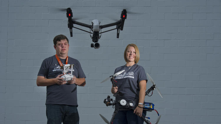
Unexpected moments of tranquillity, like finding yourself in a near-empty Roman arena during a heat wave, are becoming more and more elusive. If someone isn’t about to inadvertently impale you with a selfie-stick, another may catch you on video with a recreational drone, like the DJI Phantom (about $500 to $1,600), which is easy to use (unless you’re inebriated, like the man who crashed a Phantom on the White House grounds in January).

Yet what travelers are seeing today — remote-controlled drones bobbing around tourist sites, near airports, in the Floridian National Golf Club in Palm City while President Obama played golf — is but the tip of the iceberg. Think remote-controlled drones and selfie-sticks are intrusive? Prepare for the selfie-drone.

This next generation of drones, which are just beginning to roll out, doesn’t require users to hold remote controllers: They are hands-free. Simply toss them in the air, and they will follow you like Tinker Bell. With names such as Lily (around $700 on pre-order) and Nixie (not yet available for pre-order), they are capable of recording breathtaking video footage and trailing adventure travelers across bridges and streams, down ski slopes and into secluded gardens.

Nixie, which you can wear on your wrist until you want to fling it off for a photo or video, has a “boomerang mode” that allows it to fly back to you as if it were a trained raptor. A promotional video for Lily shows a man with a backpack lobbing the drone like a stone over a bridge and casually walking away, only to have the thing float up and follow him. Think you can outmaneuver the contraption in white-water rapids? Lily is waterproof. I watched with awe a video of Lily being dumped into a river beside a woman in a kayak (where one assumes Lily will perish), yet within seconds emerging and rising, like Glenn Close from the bathtub in “Fatal Attraction.”

There is no denying that the latest drone technology is impressive. And the footage is striking. Adventure travelers who wish to watch themselves scale Kilimanjaro or surf in Hawaii along the North Shore of Oahu will no doubt want one. But if selfie-drones become staples of every traveler who can afford them, we stand to lose more than we stand to gain when it comes to privacy, safety and quality-of-life factors like peace and beauty.

Imagine sunsets at the lake or beach with dozens of selfie-drones cluttering the sky, each vying for that perfect shot. Picture canoodling on a seemingly remote park bench during your romantic getaway and ending up on video. The intimate walks and tête-à-têtes that call to mind Jane Eyre and Mr. Rochester would hardly be the same with drones whizzing by. Think of your children building sand castles and being videotaped by passing drones. Who will be watching and recording us, and where will that information end up?

I shudder to think of 17- and 18-year-olds receiving drones for Christmas and on their winter vacations crashing the contraptions into unsuspecting sunbathers. Or themselves. Lest you think I joke, consider that in May the singer Enrique Iglesias, who is well past his teenage years, sliced his fingers while trying to snap a photo with a (remote-controlled) drone during his concert in Mexico.

Strolling Sheep Meadow in Central Park in New York on a warm spring day is already an art with all of the dodging of footballs and Frisbees one must perfect to survive. Throw in selfie-drones, and I may have to buy a flaneur’s helmet. Why not? If a drone is in midair when its battery dies, it falls from the sky.

Pitfalls abound. Yet when it comes to travel, there is no greater concern than drone use near airports. The Federal Aviation Administration said in August that pilot reports of close calls with drones had increased drastically in 2015, to more than 650 sightings by Aug. 9, up from 238 in all of 2014.

“Pilots of a variety of different types of aircraft — including many large, commercial air carriers — reported spotting 16 unmanned aircraft in June of 2014, and 36 the following month,” the F.A.A. said in a statement. “This year, 138 pilots reported seeing drones at altitudes of up to 10,000 feet during the month of June, and another 137 in July.”
2 weeks ago, I made the hike to Blanca Lake, in the Henry M. Jackson Wilderness in Washington’s Cascades. This a glorious glacier-fed lake…
What happens when morons (and lets face it, these days, it seems that a disproportionate number of travelers are morons) start flying those…
I recently had a close encounter with a whiny recreational drone near an otherwise peaceful marsh on Cape Cod. The operator (a middle-aged…

Drones have been spotted near all of the New York area’s major airports, including John F. Kennedy International, La Guardia and Newark Liberty International in New Jersey. Last year, pilots on major carriers reported seeing drones 100 feet off a wing (Delta) and flying under the plane’s nose (JetBlue).

The Global Gateway Alliance, a New York and New Jersey airport advocacy group, said in a news release that the high number of drone incidents in the New York airspace accounted for almost a third of all close-calls nationwide. In August, the alliance called for steps to make drone use safer in the wake of various incidents that the group said put passengers, planes and airports at risk. The steps include stricter enforcement of “No Fly Zones,” better drone technology, mandatory training for drone users, air-traffic-control monitoring, and education for people who live near airports about the dangers and penalties of flying drones in the area.

“It defies reason that unmanned aircrafts are putting the lives of thousands of passengers in danger without clear consequences,” Joe Sitt, the chairman and founder of the alliance, said in a news release. “It is past time for the F.A.A. to step up and protect the nation’s most crowded airspace for the 117 million passengers who use it every year.”

The F.A.A. has certain rules in place for recreational aircraft use, but it is obvious from the close-call statistics that plenty of drone operators are unaware of them or ignore them. In May, as legions of tourists prepared to visit Washington, D.C., and the area for summer vacations, the administration issued a news release saying that Washington was a “no drone zone.”

“Enjoy your visit to the nation’s capital,” the F.A.A. said. “Bring your family, your cameras and plenty of sunscreen. Just don’t bring your drone.”

Can we extend that to the rest of the states, not to mention Roman amphitheaters in the French countryside? As an admirer of travel videos, I am wowed by the capabilities of the selfie-drone. That doesn’t mean I care to watch play-by-play footage of my vacation. Or spend that vacation hauling a drone in my handbag. Alas, the genie is out of the bottle. The selfie-drone is coming.

All I can do now is make a wish: that certain beaches, gardens and ancient ruins become no-drone zones, too, so that travelers who appreciate tranquillity may be lucky enough to steal a quiet moment in them.


http://www.nytimes.com/2015/09/06/travel/selfie-camera-drones.html?_r=1
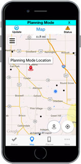
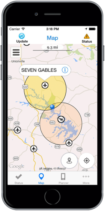
B4UFLY Smartphone App

thumb1

Beta test now underway

B4UFLY is an easy-to-use smartphone app that helps unmanned aircraft operators determine whether there are any restrictions or requirements in effect at the location where they want to fly.
On August 28, 2015, the FAA released B4UFLY to approximately 1,000 beta testers, including members of industry, government, and the public.

This limited beta test is expected to run for several months, after which the FAA plans to make a final version of B4UFLY available for the general public. The beta version of the app is for iOS devices only, but the FAA intends to release a future version for both iOS and Android devices.
Key features of the B4UFLY app include:

A clear “status” indicator that immediately informs the operator about their current or planned location. For example, it shows flying in the Special Flight Rules Area around Washington, DC is prohibited
Information on the parameters that drive the status indicator

A “Planner Mode” for future flights in different locations

Informative, interactive maps with filtering options

Links to other FAA UAS resources and regulatory information

For more information, view the B4UFLY Q&A(PDF).

http://www.suasnews.com/2015/08/38175/b4ufly-smartphone-app/

https://www.faa.gov/uas/b4ufly/media/UAS_B4UFLY_QandA.pdf


No, Part 107 Does Not Fix Everything.

proposed-drone-rules2-300x300

Since Part 107 is coming out in the next 1-3 years, will anyone use the Section 333 process anymore?

Many people mistakenly believe that Part 107 is the answer to all their needs. This is not true as there are certain types of operations that are not covered under Part 107 which leaves individuals and business with only one alternative – Section 333.

Part 107 does NOT cover:

  • Beyond Visual Line of Sight
    • Power line inspections in those really remote areas
    • SAR
    • Firefighting
  • First Person Viewing
  • Night Operations
    • SAR
    • Firefighting
    • Inspections using thermal equipment in hot environments
    • Cinematography for tv/movie scenes
    • Inspections on critical time/sensitive material (example: turbidity monitoring for dredging operations)
    • Sports
  • 55 pounds and heavier
    • Package delivery
    • Crop dusting
    • Firefighting retardant delivery
    • High-end LIDAR to monitor crops such as lumber. The LIDAR is used to detect the diameter of the wood so the loggers know which forest to harvest first.
    • Cinematography (Dual Red Epics for 3d filming or full Arri Alexa with lens and large stack of batteries for extra flight time.)
  • 500ft and higher
    • Large radio towers
    • Large bridges (Gold Gate Bridge is 746 feet above the water)
    • Large buildings (Inspecting the facade of large buildings and also the towers on top of the buildings).
  • 100 mph and faster
    • Survey large areas fast
    • Fast package/medical delivery
  • Operation Over Persons
    • Concerts
    • Live News Events
    • Sports
  • Operations from a moving vehicle
  • Aircraft conducting an external load operation (carrying stuff outside the fuselage).
    • Life preserver
    • Medical supplies
    • Tree lifting
    • Supply dropping
  • Any aircraft towing another aircraft or object
    • Banner tower
    • Glider tower
  • Operations conducted outside the United States
    • Delivery to boats outside of the United States’ territorial waters.
    • Delivery to Caribbean Islands near Florida, Puerto Rico, or the U.S. Virgin Islands.
    • Delivery to Canada or Mexico
  • Training provider of one of the above types of operations.

So if you are currently thinking these areas could be potentially beneficial or lucrative, I would suggest looking into getting a 333 exemption for one of these types of operations because when the competition floods into the market when Part 107 becomes final, these areas will remain untouched.

http://jrupprechtlaw.com/

How this newly formed Jacksonville drone company plans to separate itself from the pack

Jennsen Werley

Aeritek uses an S900 drone with a DSLR camera attached. A pilot and a camera operator can… more

As drones in Jacksonville steadily become more popular, at least one new company believes it has a simple plan to stay unique in the crowd.

“It’s our quality of work and customer service,” said Grant Ward, one of the co-founders of Aeritek, the Jacksonville-based drone company formed last year.

Aeritek, or Aerial Imaging Technology, recently received its Federal Aviation Administration Section 333 exemption, which means it has permission to use drones for commercial work. Already, it has completed a major five-day video project for Dutch shipping company Spliethoff, filming the company’s ship docked at Savannah for a promotional and training video.

Using a six-rotor DJI S900 drone, valued at about $12,000, Aeritek can shoot video in 4K and photos at 12 megapixels.

But Aeritek isn’t just settling for commercial photography. Kevin Barth, the company’s other co-founder and vice president of flight operations, said the group’s main goal is to get into mapping, where customers such as farmers can use a drone to collect data on their field, have that data analyzed and learn what portions of their acreage may need more chemicals or fertilizers.

“We want to be a one-stop shop,” Barth said. “Where you can buy, we can build and customize for you. We can help with support and maintenance. And we can process the data and produce a meaningful report.”

That part of Aeritek’s business model is less than six months from its debut, as the company finishes its final touches on the program before rolling it out to customers.

“We’re developing a turnkey operation,” Ward said. “We want to give them the whole package.”

In the meantime, both men are planning to use their expertise and experience to not only shape their company, but also to shape the new industry of commercial drones.

Ward, a long-time photographer with a background in electronics engineering, has been flying unmanned craft for years. He started with radio-controlled helicopters before he began building his own drones.

Barth is a graduate of Jacksonville University’s aviation management program, and forms the company’s flight plans. He said his interest is in forming policy, and hopes Aeritek can be one of the pioneers to help write drone policy and regulations.

“The technology is there,” he said. “The policy and infrastructure just need to be developed.”

Aeritek uses an S900 drone with a DSLR camera attached. A pilot and a camera operator can… more

As drones in Jacksonville steadily become more popular, at least one new company believes it has a simple plan to stay unique in the crowd.

“It’s our quality of work and customer service,” said Grant Ward, one of the co-founders of Aeritek, the Jacksonville-based drone company formed last year.

That quality of work — made possible by the more expensive, heavier multi-rotor drones carrying digital single-lens reflex cameras the company uses for photos and videos — is getting notice.
Aeritek, or Aerial Imaging Technology, recently received its Federal Aviation Administration Section 333 exemption, which means it has permission to use drones for commercial work. Already, it has completed a major five-day video project for Dutch shipping company Spliethoff, filming the company’s ship docked at Savannah for a promotional and training video.

Using a six-rotor DJI S900 drone, valued at about $12,000, Aeritek can shoot video in 4K and photos at 12 megapixels.

But Aeritek isn’t just settling for commercial photography. Kevin Barth, the company’s other co-founder and vice president of flight operations, said the group’s main goal is to get into mapping, where customers such as farmers can use a drone to collect data on their field, have that data analyzed and learn what portions of their acreage may need more chemicals or fertilizers.

“We want to be a one-stop shop,” Barth said. “Where you can buy, we can build and customize for you. We can help with support and maintenance. And we can process the data and produce a meaningful report.”

That part of Aeritek’s business model is less than six months from its debut, as the company finishes its final touches on the program before rolling it out to customers.

“We’re developing a turnkey operation,” Ward said. “We want to give them the whole package.”

In the meantime, both men are planning to use their expertise and experience to not only shape their company, but also to shape the new industry of commercial drones.

Ward, a long-time photographer with a background in electronics engineering, has been flying unmanned craft for years. He started with radio-controlled helicopters before he began building his own drones.

Barth is a graduate of Jacksonville University’s aviation management program, and forms the company’s flight plans. He said his interest is in forming policy, and hopes Aeritek can be one of the pioneers to help write drone policy and regulations.

“The technology is there,” he said. “The policy and infrastructure just need to be developed.”


http://www.bizjournals.com/jacksonville/news/2015/08/28/how-this-newly-formed-jacksonville-drone-company.html#i1

FAA Starts Beta Testing App That Tells Drone Pilots Where They Are Allowed To Fly

iPhone-6-3Earlier this year, the Federal Aviation Administration (FAA) announced that it would soon start beta testing an app that would help drone flyers understand where they can and — more importantly — can’t fly. Today, the FAA announced a few more details about the app and launched the first beta version of the aptly named B4UFLY app for iOS.

Sadly, though, this is still a private beta test that will likely run for two months. For now, the app will be iOS-only, with an Android version to follow at an unspecified date.

It looks like the private beta is currently oversubscribed, but you can still get on the waiting list by emailing b4ufly@faa.gov to request an invite.

Judging by the screenshots the FAA posted today, the app is going to be pretty easy to use. The main purpose of the app is to tell you whether you are too close to an airport, in a national park (where drone flights are now forbidden), or another restricted area to fly your drone (or “unmanned aerial vehicle” or “remote controlled quadcopter” if you don’t like the word “drone”).

The app will let you both plan future flights and check whether there’s any issue with your current location. That’s about it — but that’s also all you really need to know.

If you’re within five miles of an airport, you can only fly after you notify the airport operator or talk to air traffic control. Chances are you don’t want to do that, so you better stay out of those areas. The FAA says future versions of the app will include a system for notifying air traffic control of your intent to fly within this five-mile zone.

Because this is such a problem for drone pilots who don’t want to end up in local news reports, a number of services and apps like Hover have sprung up over the last few years that also show drone pilots where they can and can’t fly. DJI’s Phantom drones won’t even take off if they are in some restricted drones. Chances are, though, that an official authoritative app from the FAA will give pilots a lot more confidence than third-party services.

And because it’s that time of the year — remember to never fly your drone close to a wildfire either.