A drone school is opening later this month and offering classes in B.C.’s interior.
Over the last decade, the use of unmanned aerial vehicles or ‘drones’ have drastically expanded, but the regulations and training have continued to lag behind.
Ernie Zeisman and his business partner Ron Wyres decided to begin offering courses for people wanting to learn how to fly drones commercially.
They will be operating out of a commercial airport in Grand Forks, B.C.
“They are getting extremely popular and the problem is you can buy them off the shelf,” said Wyres.
“Most people don’t realize you have to have training, have insurance and be qualified under Transport Canada.”
Zeisman gravitates towards drones for jobs like power line inspections, which he says are cheaper and safer than helicopters.
Their announcement comes on the heels of yet another close call last week when a drone almost hit a seaplane flying over Vancouver.
In the meantime, Transport Canada continues to review this country’s drone regulations.
“It’s the wild west right now and they are trying to figure out how to get a handle on it,” said Wyres.
– See more at: http://digital.asiaone.com/digital/news/drone-racing-takes#sthash.c3aUWlsA.dpuf
Benson Ang
It is not the Clone Wars in Star Wars, but it is close.
Drawn to the adrenaline rush, speed and thrill of piloting drones, groups of men mostly in their 30s and 40s are spending their weekends at open fields in Punggol, Old Holland Road and Tuas to see who can fly the fastest and most skilfully.
In drone racing, a CCTV camera installed on each drone transmits video via radio signals to a mounted monitor or special video goggles.
Racers watch this video and see the world from the drone’s perspective.
They also control the drones, which can fly over obstacles and do stunts such as turns, somersaults, dips, flips and barrel rolls.
The drones can go up to 120km an hour – faster than a speeding car.
Says an enthusiast, PhD researcher Ervine Lin, 33: “When you are darting under obstacles and flying close to the ground, it gets the adrenaline pumping.”
Adds another racer, sports consultant Mohammed Zacky, 35: “It’s an immersive experience, like you’re strapped in the machine yourself. You can go anywhere, in any direction.”
A spokesman for the Civil Aviation Authority of Singapore (CAAS) says those seeking to race drones in Singapore have to apply for permits.
She says: “There are significant safety risks from drone racing, such as the speed at which the unmanned aircraft is operated and the proximity to spectators of the unmanned aircraft during the race.
“CAAS will issue the necessary permits only if we are satisfied that safety risks will be adequately addressed.”
Typically weighing about 500g each and measuring 30cm in diameter, racing drones are smaller and lighter than those used for photography.
They are available at some hobby shops here, and racing drones are also cheaper and can cost from $300 to $1,000. The pricier models are generally lighter or have more powerful engines.
Mr Garry Huang, 34, owner of Drone Matters, a local company which customises and sells racing drones, says: “It’s common for drones to crash to the ground or into a tree.
“The drone’s body – typically made of carbon fibre – can withstand such crashes. You usually need to replace only the propellers, which cost $1 or $2 each.”
In recent years, the sport has caught on in countries such as New Zealand, Australia, Germany, the United States, China and Japan.
Enthusiasts say the informal weekend races here started last year. According to estimates, there are more than 500 drone racers here – all of them amateurs. Some drone interest groups organise meet-ups through their Facebook pages or WhatsApp group chats.
Official drone races have also been held here.
One, organised by the Infocomm Development Authority of Singapore, took place at Suntec Singapore Convention & Exhibition Centre in April this year and drew about 80 participants.
Another, organised by Singapore Polytechnic’s aviation club, took place on the institution’s premises two months ago. It had 24 participants.
Those in the open category had to race around a track, flying over obstacles and under airgates. They also had to perform tight, 270-degree turns with precision and speed.
University student Wong Wen Jie, 23, emerged champion in the category, winning $2,000 worth of drone parts.
He says: “To win, you need not only speed, but also skill. If you go fast but cannot corner well, you will fly off the course and get disqualified.”
Every weekend, he races with a group of friends. About 10 of them usually show up, although only four can race at any one time without radio-frequency interference, he says.
Under the Unmanned Aircraft (Public Safety and Security) Act, which came into force two months ago, drone operators need an operator and an activity permit from CAAS to fly an unmanned aircraft that weighs more than 7kg, or for any business purpose, or if the operation is not recreational in nature or for research.
Says the CAAS spokesman: “The definition of recreation excludes organised group sporting activities such as drone racing.”
The drone racers Life spoke to say they intend to abide by the rules. There have been no instances of damage to property, they say, even when their drones crash.
Says Mr Wong: “We are very particular about safety and generally hold our races in places that are deserted anyway.
“We don’t want our drones to interfere with other people or want others to interfere with our race.”
Catch the thrills of drone racing in this video str.sg/ZnGB
– See more at: http://digital.asiaone.com/digital/news/drone-racing-takes#sthash.c3aUWlsA.dpuf
Figure 1: For airborne precision agriculture applications, the spectral range most desired is the VNIR, which spans 400 to 1,000 nm. Image: Headwall Photonics Inc.
The push to make food and poultry products safer, more wholesome and more plentiful is leading to new initiatives commonly described as “crop science” and “precision agriculture.” Although there are many facets to these initiatives, the ability to “see” the desired field of view with a high degree of spectral and spatial resolution can lead to many scientific breakthroughs that benefit the global community.
In some cases, the desired field of view can be an entire crop field or vineyard as seen from an aircraft or unmanned aerial system (UAS). In other cases, it can simply be crops or poultry moving at rapid speed mere feet away along a conveyor line. Characteristic of both is motion, which allows a sensor (either multispectral or hyperspectral) to capture frames of high-quality spectral image data that can be analyzed later. A complete representation is called a hyperspectral data cube, which is a stack of images of the same object or scene—essentially an image for each wavelength.
The practical difference between multispectral and hyperspectral primarily lies in the number of spectral bands captured. Multispectral imaging captures between five to 30 bands, with gaps between those bands. Hyperspectral captures hundreds, with very dense and continual spectral information for each pixel in the image. In some cases, one will be more desirable to the other. However, a hyperspectral sensor gives the option of “seeing” everything. Spectral signatures are powerful discriminators, and it’s useful to know when a particular chemical fingerprint is there or not. There are many instances where the granularity and specificity of hyperspectral image data is absolutely necessary.
Hyperspectral imaging has the unique ability to extract meaningful scientific information from the scene or field of view. It allows users to detect the presence of a material based on its spectral fingerprint. It also allows users to classify and separate materials into spectrally similar groups. Discrimination, characterization and quantification are also hallmarks of the technology.
The ability of hyperspectral sensors to exhibit a high degree of discrimination means scientists can classify those disease conditions, and also build an image that faithfully pin points where it is and how invasive it might be. Since the image data is GPS-coordinated and orthorectified during post-processing, the scientific value is significant: irrigation and fertilizing decisions are more precise, speciation is more accurate and crops that might be lost are saved. Indeed, the very same hyperspectral imaging technology that can make existing crop harvests more bountiful can also help survey the land in famine-affected areas so crops can be planted with a higher degree of success.
Since motion is needed for hyperspectral imaging to create a data cube, it meshes perfectly with the rapid growth of the UAS across industry, research and academia. The UAS is more affordable, smaller and lighter than fixed-wing manned aircraft and, thus, is more readily deployable in unforgiving areas of the world. Armed with precise instrumentation, such as hyperspectral sensors, a UAS can deliver truly life-enriching information beneficial on a global scale. Entire economies depend on the success of agriculture: citrus in Florida; coffee in South America; vineyards in northern California. Across them all, UAS with hyperspectral sensors are deployed at a rapid pace.
One common mistake prospective users make is misjudging the work needed to integrate the entire flight/sensor package. Obviously, size and weight matter because a UAS, especially the small hand-launched ones, will typically have a strict payload limit. Hyperspectral sensor manufacturers, such as Headwall Photonics, recognize this and are making their instruments small, light and more integrated. For example, Nano-Hyperspec (Figure 1) is only 3 in x 3 in x 4.7 in and weighs less than 1.5 lbs. But, in that small space sits the data storage chip, and the GPS attaches directly to the sensor rather than connected by cables that take up space and add weight. In addition to smaller and more integrated sensors, Headwall also helps to fully integrate the flight package. This means not only the sensor, but also helping with the UAS, the GPS and, if desired, LiDAR instrumentation. LiDAR is a common add-on for precision agriculture work and other remote-sensing research.
Figure 2: Diffraction grating. Image: Headwall Photonics Inc.
The value of this integration work is a quicker time to deployment and more success with capturing precise image data. This work also turns a basic UAV or “drone” into a useful UAS.
For airborne precision agriculture applications, the spectral range most desired is the visible/near-infrared (VNIR), which spans 400 to 1,000 nm. Most everything worth seeing can be seen in the VNIR range; but occasionally the shortwave infrared (SWIR), from 900 to 2,500 nm, provides useful data. One option is to simply have two sensors capturing the respective VNIR and SWIR image data, both controlled simultaneously by hyperspectral image software. Another is to have an integrated dual sensor package that co-registers the pixels from each sensor, producing data from 400 nm up to 2,500 nm. While heavier and larger than the Nano, it’s perfectly suitable for bigger UAVs and fixed-wing manned aircraft.
The basic design of a hyperspectral sensor is shown in Figure 2. Reflected light passes through a lens, then through an image slit, which allows a sliver of the scene, image to reach a curved concentric mirror. A high-performance diffraction grating then diffracts the reflected light precisely, and without any unwanted artifacts or aberrations, onto a second concentric mirror, which images the sliver of the scene image onto a camera focal plane array (FPA), but with spectral information spread in the direction perpendicular to the slit direction. By recording this spectral data for that one sliver of the scene and repeating this while moving either the sensor or the scene to capture the spectral data for the next adjacent sliver of the scene image, the hyperspectral image of the full scene can be captured. The spectral range of the sensor is dependent on the FPA technology: silicon (300 to1,100 nm), indium gallium arsenide (InGaAs) (700 to 1,700 nm), indium antimonide (InSb) (1,000 to 5,000 nm) and mercury cadmium telluride (MCT) (1,000 to 1,4000 nm). Hyperspectral sensors of this type are often referred to as line scanners, and the design described above is a concentric one. Because there are no moving parts within the sensor, the resulting instruments are robust and stable across temperature.
Figure 3: Aberration-correction is a very desirable feature made possible through precisely engineered diffraction gratings. Image: Headwall Photonics Inc.
Aberration-correction is a very desirable feature made possible through precisely engineered diffraction gratings. The job of the grating is to diffract the light precisely, and this is accomplished by the design of the grating and its groove profile. Gratings can be planar, convex or concave, and the groove profiles are precisely engineered so each grating is application-specific. They can also be engineered in very small sizes, meaning the instruments that contain them are similarly small and light. Figure 3 depicts the basics of a diffraction grating.
The natural tendency is for image degradation to occur off to the edges of the field of view. These aberrations are corrected by the diffraction grating, meaning the entire wide field of view is crisp from one edge to the other. For UAS deployment, this is crucial, because it can actually help optimize the flight efficiency since fewer passes over the field are needed in order to faithfully and sharply capture all the image data the sensor sees.
Hyperspectral imaging isn’t limited to airborne deployment. The technology is also used along inspection lines for high-value specialty crops, such as nuts and fruits, and for poultry and seafood. In fact, the USDA is working with Headwall Photonics to push the science of hyperspectral imaging forward with the goal of improving the inspection accuracy of poultry. The end result is a new technology that delivers higher-quality food products to consumers, while delivering demonstrated differentiation and maximized value to producers.
Thanks to their ability to “see” with a high degree of specificity and discrimination, hyperspectral sensors can spot anything other imaging and vision techniques might miss. The sensors can also “grade” harvested crops in a manner that allows the producer to maximize yields.
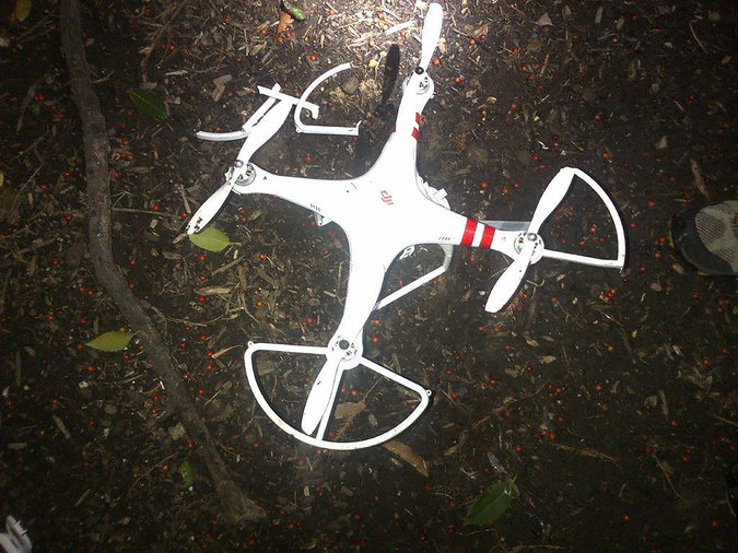
A drone buzzing over New Jersey was spotted by four pilots near Newark Airport around noon Sunday.
The planes were about 13 miles from the airport and more than 2,000 feet in the air when they encountered the drone, according to the Federal Aviation Administration.
All the flights landed safely.
It was the latest in a series of such encounters involving planes flying into and out of the New York’s airports.
Firefighters in B.C. are testing out a small camera-equipped drone as a way to save time during rescues.
Langford B.C. firefighters used a borrowed drone on the weekend while rescuing a hiker who fell about six metres down the side of a mountain, suffering serious injuries including a broken leg.
The drone was able to fly up close to the patient and assess the hazards facing rescuers, despite misty weather that made flying a full-sized rescue helicopter difficult.
Langford Fire Chief Bob Beckett said the drone wasn’t essential to this particular rescue, but it showed the potential to speed up the process.
Beckett said he believes the drone could also be used to fight forest fires.
“It convinced me that this is a tool that the fire service will probably rapidly invest in,” Beckett said.
On the other side of the country, in Dieppe, N.B., the local fire department has already purchased a drone, which is being used as part of a pilot project to see whether it is useful during fires.
An industry group representing hobby model airplane enthusiasts since 1936 has asked federal agencies to stop characterizing their members as the irresponsible drone pilots who interfere with aircraft fighting wildfires.
The Indiana-based Academy of Model Aeronautics said in December that it created a “Know Before You Fly” campaign to educate the “legions of new ‘drone’ fliers taking to the skies.
“Our concern is that our members are broad-brushed with a small number of irresponsible people that don’t know the rules,” Richard Hanson, AMA government and regulatory affairs representative, said in a recent telephone interview.
In the letter, the group blamed recent drone confrontations — several which occurred in the skies over San Bernardino County — to enthusiasts who have disregarded public safety.
“Errant consumers flying in an unsafe manner do not represent the organized hobbyist community,” said the letter to the top administrators of the Federal Aviation Administration, U.S. Forest Service and the U.S. Bureau of Land Management.
Hanson said drone pilots who interfered with wildfire-fighting efforts in Southern California have been referred to as hobbyists when it is not known who they really are.
“They could be someone hoping to sell their images to a news media outlet or someone seeking to get known on YouTube,” Hansen said.
Late last month, as drone legislation traveled through Congress and the state Legislature, San Bernardino County supervisors set aside $75,000 in potential reward money for tipsters who would help authorities arrest and convict drone operators who interfered with firefighting efforts at three recent wildfires.
At the Lake, Mill2 and North fires, firefighting aircraft were temporarily grounded because drones flew above the fires, presenting a hazard to pilots.
At one point in the North fire, five drones were spotted above the blaze. As a result, planes and helicopters that drop flame retardant or water were ordered away from the area for pilots’ safety.
“Our more than 176,000 members know where to fly and where not to fly,” the letter said. “They know how to check for temporary flight restrictions, such as those put in place around wildfires, and to stay well clear of any unmanned aircraft.”
The website knowbeforeyoufly.org has a newly created click-on icon explaining the importance of not flying near wildfires, Hanson said.
The AMA has negotiated agreements with two of three major drone manufacturers to put educational materials about regulations and safe flying practices inside boxes containing drones and related parts, Hanson said.
Negotiations are proceeding with the third, he said.
At a recent industry trade association meeting in Atlanta, the organization began enlisting the help of major retailers and web distributors to help get the message out, Hansen said.
“The FAA commends the Academy of Model Aeronautics (AMA) for its commitment to safety and education,” said FAA spokesman Ian Gregor. “It is critical that all hobbyists adhere to the AMA’s rigorous standards to ensure that model aircraft operations pose no hazards to manned aircraft or to people on the ground,” Gregor said. “We value our partnership with the AMA and will continue to work closely with them to promote safe model aircraft operations.”
Some members of the AMA are concerned that new laws proposed in several states could endanger the opportunity for its members to fly model aircraft.
Don Baligad, a Yucca Valley resident who purchased his first drone about six months ago, said he believes that some of the drones in the skies could be from news organizations or governmental agencies.
John Miller, a spokesman for the San Bernardino National Forest, said his agency does not use drones in California.
When a government intelligence staffer managed to crash his DJI Phantom drone on White House property, the Chinese manufacturer took the decision to issue a no-fly zone over the DC area. DJI already used GPS to implement invisible demarcations stopping users flying their machines into no-fly zones like airports, forcing them to land when they hit certain coordinates.
Unfortunately, as noted in a FORBES report on smartphone issues yesterday, there’s a vulnerability in GPS affecting most commercial drones that would allow a nearby hacker to spoof signals, change coordinates and commandeer an Unmanned Aerial Vehicle (UAV) and take it wherever they wanted, whether that’s the White House or Dulles airport. That’s according to researchers from China’s Qihoo, who demonstrated their attacks using the free and open source GNU Radio, amongst other tools, to alter the GPS coordinates on a DJI Phantom 3. Thanks to free or cheap software defined radio tools, and the old, broken GPS standard, it’s now inexpensive and relatively straightforward to carry out attacks on GPS, Lin Huang and Qing Yang warned.
Any hackers wanting to land a DJI or other drone on Obama’s lawn, or into other no-fly zones, can send spoof signals that would make it seem the UAV was in a safe zone, said Qing Yang, a member of Qihoo’s Unicorn Team TISI +%, a specialist research arm at the company that famously hacked a Tesla last year for a $10,000 prize. Being close enough to the drone to hack it would be a problem for attackers, though the Qihoo researchers set a radius of 100 metres in their tests.
Alternatively, it’s possible to take drones out of the sky by making them believe they’re in a no-fly area. In the video below, filmed from a camera on the UAV itself, the benevolent hackers do just that, forcing it to crash land
ATTLEBORO, Mass. (MyFoxBoston.com) — In Attleboro, police will soon take to the skies. The city has not purchased a helicopter, but it is using new technology to help keep its citizens safe.
Chief Kyle Heagney said buying drones are less expensive than buying a helicopter. He recently bought two of them, for less than $6,000, and is training five officers to use them. The money for the drones came from drug forfeiture money, police say, but haven’t hit the skies yet.
“It will not replace police officers, it will enhance our search capabilities and certainly allow us one day to save a life,” Heagney said.
The drones are guided by GPS technology and feature hi-definition cameras. They are easy to fly and produce highly detailed quality images.
Help Incorporated, a Plainville security company and Drone UAV Academy of Foxboro are both helping Attleboro police set up what will be their own flight wing.
Craig Cooley from Help Inc. said they give you a “birds eye view.”
“It’s literally a whole different perspective when you are looking at things from above,” he said.
And Attleboro’s police chief said he is sensitive to privacy issues and will only use the drones for search and rescue efforts or to keep one of his officers safe in a dangerous situation. And he’s certain that other departments will soon start to follow suit.
Spain is reportedly set to acquire four Reaper surveillance drones from General Atomics, a move that will make the country the fifth European nation to benefit from the US-made unmanned aircraft vehicle (UAV).
Agence France Presse cited Spain’s Defence Ministry as saying that its defence budget for the next year has included €25m ($27m) for the acquisition of four reconnaissance drones and two ground stations.
Spain has announced a total budget of €171m for a five-year drone programme.
A ministry spokesman was quoted by the news agency as saying: “This type of equipment is necessary in operations today.”
For this project, General Atomics will collaborate with Spanish engineering firm Sener, the ministry official added.
The Reaper surveillance drones are designed to perform strike, coordination, and reconnaissance against high-value, fleeting, and time-sensitive targets.
Currently, in addition to the US, the countries using the Reaper system include the UK, France and Italy. Moreover, the Netherlands has recently placed orders for this UAV system.
“The Reaper surveillance drones are designed to perform strike, coordination, and reconnaissance against high-value, fleeting, and time-sensitive targets.”
The weaponised drones have been used extensively by the US for counter-terrorism operations in Afghanistan, Pakistan, Somalia, Syria, Iraq, and Yemen.
However, Spain is expected to purchase an unarmed version of the UAV, AFP reported.
Meanwhile, Germany, France and Italy recently signed a declaration of intent (DoI) to carry out a definition study worth up to €1bn into the European developed medium altitude/long endurance (MALE) unmanned aerial system.
This new development is part of a proposed European drone programme planned in 2013 to minimise dependence on the US and Israeli military technology.
Image: General Atomics’ MQ-9 Reaper. Photo: courtesy of Gerald L Nino.
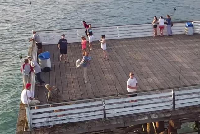
A man flying his camera drone over a pier at a San Diego beach recorded the moment a skilled fisherman cast his line and hooked the device.
https://youtu.be/SrzU-MMBGIM
The video, uploaded to YouTube by Tice Ledbetter, begins with the drone flying near a pier on San Diego’s Pacific Beach Thursday when the aircraft catches the attention of a fisherman.The fisherman watches the drone for a moment before casting his line, which becomes tangled in the drone’s propeller.Ledbetter said in a Facebook post he was baffled as to how the fishing line became tangled in his propeller until he reviewed the video footage. He said the drone was still able to fly with the line attached and it traveled about a half mile before landing.
“What a jerk! Gotta admit though, that cast was spot on!” Ledbetter wrote in the video’s description.