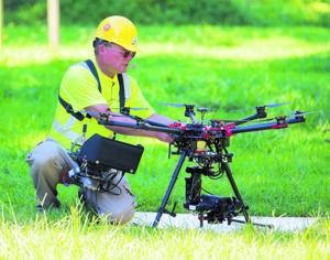
Mark Genung, chief engineer and lead pilot unmanned aerial vehicle of Hazon Solutions, operates the vehicle in White Stone on Wednesday, August 12, 2015. Dominion demonstrated its drone program on live wires.
Posted: Sunday, August 16, 2015 8:00 am
WHITE STONE — The buzzing drone hovers 80 feet in the air and beams down a video so clear that each thread on a bolt 15 feet away is distinguishable.
With the dual blades on each of its eight arms spinning furiously while hoisting a high-tech video camera, this 25-pound flying contraption is replacing bucket trucks and helicopters for power-line inspection by Dominion Virginia Power.
And the giant utility isn’t the only organization banking on small unmanned aircraft to change the way they do business.
Drones are being used across the state and nation to do routine inspections of other ungainly structures such as cellphone towers and railroad bridges, often in a cheaper, faster and safer way than traditional methods. They fly over crops to help farmers see which areas need more water or fertilizer or to detect pest infestations early. And they could soon help emergency workers as they search for missing people or fight large fires.
The fledgling commercial drone industry is also finding a home in movies, real estate companies and other areas that see a benefit from overhead video, even as it’s limited by strict Federal Aviation Administration regulations keeping the aircraft no higher than 200 feet and within sight of the pilot.
The line-of-sight rule is the main obstacle for Dominion expanding its drone program to its emergency operations, where a drone could theoretically survey storm damage so the company would know exactly where and with what equipment to send its repairmen.
The utility could also use drones to inspect pipelines, rights-of-way and components of its power plants, Eisenrauch said.
About a thousand companies nationally have been granted the waiver that allows commercial use of drones, with a few dozen of those based in Virginia. The FAA is developing regulations, expected to be released next year, that will determine how companies can expand drone use while also ensuring safe operation in the national airspace.
Researchers at Virginia Tech are studying how to use drones for three-dimensional mapping that can identify terrain and buildings by type. They’re also trying to use special cameras to more quickly and accurately identify radioactive sources. Eventually, they hope to create software that will allow farmers to submit drone photos of their wheat and corn fields to identify fungus or other outbreaks.
The entire highway and railway systems in Virginia could eventually be inspected by high-speed drones, said Kevin Kochersberger, director of Virginia Tech’s Unmanned Systems Lab.
“The real advantage we see are that this could greatly speed up inspection, reduce cost and improve maintenance on the highway and transportation systems, as well as assessment of urban areas,” Kochersberger said. “(And) It’s not invasive. You’re not going to be blocking rail traffic or highway traffic in the process of inspecting these environments.”
Amazon has announced plans to deliver packages to customers’ doorsteps using drones. Kochersberger, the Tech researcher, said he’s more convinced than ever that precision delivery could one day be more than a dream. His lab is creating a student competition to see who can design the best doorstep delivery drone.
But the days of drones replacing mail carriers are likely a decade or more away as the industry works to develop the technology to allow drones to sense and avoid obstacles and persuades the FAA it’s safe, said Jon Greene, associate director of the Mid-Atlantic Aviation Partnership.
And while package delivery may not be available soon, Greene said he expects the various uses of drones to continue expanding.
http://www.heraldcourier.com/news/local/drone-industry-expands-over-virginia/article_74e5090a-43b3-11e5-9bb8-87f01da09bac.html