Aerial Photography
Drone Technology Aids in Discoveries at Medieval Irish Sites
Jeanette Grider
Unmanned aerial vehicles (UAV) have been gaining attention in the news for the last few years, but archaeologists like Saint Louis University history professor Thomas Finan, Ph.D., have always appreciated what aerial photography could accomplish.
Finan says UAV technology, along with high speed computer applications and mapping software, and sensors that can collect multi-spectral image are changing archaeology, adding that unmanned aerial survey is the next great jump in archaeological technology.
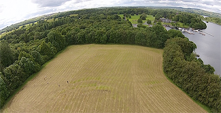
For nearly 20 years, Finan has spent summer breaks on archaeological digs, often taking SLU students to areas such as North Roscommon in Ireland in search of ancient sites, relics and a deeper glimpse of history.
Finan has now partnered with Paul Naessens, director of Western Aerial Survey, and a field archaeologist he has worked with for two years in North Roscommon, to further their exploration through the use of UAVs.
“Paul is not only a great archaeologist,” said Finan. “He is fully licensed by the Irish Aviation Authority to carry out these surveys and broaden our knowledge of the area.”
Finan has been working in north County Roscommon for the last two decades, conducting archaeological explorations at a number of sites, including the ecclesiastical complex at Kilteasheen, the Rock of Lough Key, the MacDermot moated site stronghold near the Rock, six ringforts (smaller agricultural settlements) and the Kilbrian ecclesiastical site. He says the landscape is breathtaking, but the archaeology is even more incredible.
“In 2013-14, we identified what we believe to be a major medieval Gaelic settlement in proximity to the Rock of Lough Key, a stunning island fortification,” Finan said. “This year, we focused our attention on some lesser known sites in the area, including a ringfort that shows great promise for medieval settlement and what appears to be a major settlement in association with the parish church at Kilbrian.”
The survey, conducted as part of an ongoing field survey of north Roscommon, brings together the latest in archaeological technology to enhance the understanding of sites that had been identified before.
“Most of these sites are found in the inventory of the National Monuments Service, but are often given cursory classification distinctions,” Finan added. “My interest is piecing together various medieval settlements (high status lordly sites, ecclesiastical sites, lower status agricultural sites) to explain social dynamics and the events of the thirteenth century in particular.”
Finan’s team uses traditional tools such as gradiometry, electrical resistivity and topographical surveys to identify features in the landscape. The aerial survey adds a completely new element to the study.
“We have collected an unprecedented amount of digital data,” Finan said. “The 3D landscape data allows us to see minute changes in the topography that can be defined as structures and human occupation. The digital data collected with the geophysics is then wrapped around that 3D data to give us an amazing understanding of what is there without sinking a spade.”
Finan says managing this data has been a challenge. The amount of data collected in aerial survey fills hard drives quickly, and dealing with archiving and storage is a major pre-occupation for the team.
“We build a great deal of redundancy into the project, but in reality the management of the data revolves around developing tools that can both archive and present the data in new ways. This is really where the cutting edge of digital archaeology is right now. We have tons of digital data, but what do we do with it? From our perspective, we have chosen to make the data freely available to anyone who wants to use it for scholarly purposes with proper attribution using an open-data policy. Our next step is to integrate that database with other archaeological information that has been collected over the years from excavations, archives and even aerial photos from a hundred years ago.”
While the project is ongoing, Finan is content with saying that the process of data collection is reaching a significant milestone after only three years.
“When combined with the rich collection of historical sources that we have for north Roscommon in the thirteenth century, this research has huge potential to change the way we understand that century. But what is more important to me is that the local population in north Roscommon appreciates this research and has been so helpful to us all these years. Farmers have told us about sites not recorded, have given us access to their lands, and have been thrilled to see students from America working in their area. It continues to be a great experience for all involved.”
For additional information, contact Dr. Finan at finantj@slu.edu
Flight Test: Dual Camera Operation – DJI Inspire 1
Drone Photography – Aerial Roadside
Aerial Cameras to Chase Exotic Car Rally Up the California Coast

LOS ANGELES, Aug. 12, 2015 /PRNewswire-iReach/ — Flying camera drones are creating amazing views of special events, parades, parties, and will be used to capture an exotic car rally. High-performance automobiles will be zooming up the beautiful highways of California, and aerial photography from LA based TLC Creative will capture the thrills of seeing the amazing cars as they race to Pebble Beach. The Italian Stampede car rally is taking place between Los Angeles and Pebble Beach, just in time for The Pebble Beach Concours d’Elegance and the Rolex Monterey Motorsports Reunion are featured at the Pebble Beach Automotive Week.
Photo – http://photos.prnewswire.com/prnh/20150812/257811
The Italian Stampede is an exotic car rally that has become a yearly lifestyle event where attendees come from all over the world and rally from Los Angeles to Monterey for a weekend of car events.
Aerial cameras are bringing exciting visuals that have never been seen before at special events and indoor and outdoor occasions of all kinds, pioneered by TLC. The aerial photography by TLC is complimented with aerial services for agronomy, NDVI vegetation health monitoring for property and for water conservation analysis. 3D mapping provides venue and property owners with detailed information and new ways to see their property. Real estate people have been using drone cameras to capture breathtaking views of high-end homes and developments. Air to ground live streaming video is an amazing new technology bringing aerial views into live events.
TLC Creative, with its 30 years of live special event technical production, is flying cameras at all kinds of special events, such as the Special Olympics Torch event that recently happened in Los Angeles. The aerial cameras are so small and quiet they can be flown at indoor events and parties, bringing a new level of video interaction for special event guests. Special events are now including aerial photography for 360 event capture and for views that bring a whole new perspective to viewers. Flying cameras at special events are creating great energy.
A high-tech, FUTURE themed wedding featured an amazing moment as a flying drone smoothly delivered the ring to the altar ceremony. That wedding also featured an array of live special effects by TLC, including a laser cone that ‘beamed’ the couple over to the reception. Flying cameras, aerial photography, 4K drones, aerial cameras, drones can be seen at TLCflyingcameras.com
Agronomy, NDVI vegetation health monitoring for water conservation is the other way aerial cameras are benefiting all types of venues and property, and TLC is creating 3D mapping to help planners see their exact property characteristics.
TLC Creative, known for special effects entertainment and reveals, such as the dramatic drop-screen cylinder of video that fills Staples Center for every home game of the Los Angeles Lakers. Video panoramas and spectacular laser and pyro shows are an everyday show making experience for TLC Creative, Los Angeles based special effects company. Corporate events and entertainment industry turn to TLC Creative for live special effects impact and unforgettable shows, laser shows and fireworks to streamers and confetti, TLC is known to add wow to events. Visit TLCisCreative.com
http://news.sys-con.com/node/3410132